Back Ledenez Cooley Breton Cooley-Halbinsel German Cooley penintsula Basque Péninsule de Cooley French Cuaille Irish 쿨리반도 Korean Cooleyhalvøya NB Cooley Peninsula Polish
Cuaille | |
|---|---|
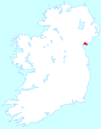
 Location of the Cooley Peninsula | |
 | |
| Geography | |
| Location | Ireland |
| Adjacent to | |
| Area | 155 km2 (60 sq mi) |
| Highest elevation | 589 m (1932 ft) |
| Highest point | Slieve Foy |
| Administration | |
| County | Louth |
| Demographics | |
| Population | 9,212 (2016) |
| Pop. density | 59.4/km2 (153.8/sq mi) |
54°2′4″N 6°13′36″W / 54.03444°N 6.22667°W

The Cooley Peninsula (from Irish Cuaille,[1] older Cúalṅge)[2] is a hilly peninsula in the north of County Louth on the east coast of Ireland; the peninsula includes the small town of Carlingford, the port of Greenore and the village of Omeath.
- ^ "Placenames Database of Ireland". Archived from the original on 20 September 2012. Retrieved 13 June 2011.
- ^ "Electronic Dictionary of the Irish Language". Archived from the original on 7 February 2019. Retrieved 6 August 2016.
© MMXXIII Rich X Search. We shall prevail. All rights reserved. Rich X Search