Back كوردوفا (ماريلند) Arabic کوردووا، مریلند AZB Cordova (Maryland) Catalan Cordova (lungsod sa Tinipong Bansa, Maryland) CEB Cordova (Maryland) Spanish Cordova (Maryland) Basque کردوا، مریلند Persian Cordova (Maryland) Italian Кордова (Мэриленд) Kazakh Кордова (Мэриленд) Kirghiz
Cordova, Maryland | |
|---|---|
Census-designated place | |
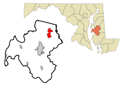
 Location of Cordova, Maryland | |
| Coordinates: 38°52′40″N 75°59′28″W / 38.87778°N 75.99111°W | |
| Country | United States |
| State | Maryland |
| County | Talbot |
| Area | |
| • Total | 4.87 sq mi (12.62 km2) |
| • Land | 4.87 sq mi (12.62 km2) |
| • Water | 0.00 sq mi (0.00 km2) |
| Elevation | 46 ft (14 m) |
| Population (2020) | |
| • Total | 551 |
| • Density | 113.10/sq mi (43.66/km2) |
| Time zone | UTC−5 (Eastern (EST)) |
| • Summer (DST) | UTC−4 (EDT) |
| ZIP code | 21625 |
| Area code | 410 |
| FIPS code | 24-19900 |
| GNIS feature ID | 0590022 |
Cordova is a census-designated place (CDP) in Talbot County, Maryland, United States. The population was 551 at the 2020 census, down from 592 at the 2000 census.
- ^ "2020 U.S. Gazetteer Files". United States Census Bureau. Retrieved April 26, 2022.
© MMXXIII Rich X Search. We shall prevail. All rights reserved. Rich X Search