Back Koromandel yarımadası Azerbaijani Coromandel Peninsula (lawis) CEB Poloostrov Coromandel Czech Coromandel Peninsula German Koromandela Duoninsulo Esperanto Península de Coromandel Spanish Coromandelgo penintsula Basque Péninsule de Coromandel French Penisola di Coromandel Italian コーラマンデル半島 Japanese
36°50′S 175°35′E / 36.833°S 175.583°E
This article needs additional citations for verification. (February 2011) |


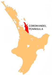
The Coromandel Peninsula (Māori: Te Tara-o-te-Ika-a-Māui) on the North Island of New Zealand extends 85 kilometres (53 mi) north from the western end of the Bay of Plenty, forming a natural barrier protecting the Hauraki Gulf and the Firth of Thames in the west from the Pacific Ocean to the east. It is 40 kilometres (25 mi) wide at its broadest point. Almost its entire population lives on the narrow coastal strips fronting the Hauraki Gulf and the Bay of Plenty. In clear weather the peninsula is clearly visible from Auckland, the country's biggest city, which lies on the far shore of the Hauraki Gulf, 55 kilometres (34 mi) to the west. The peninsula is part of the Thames-Coromandel District and the Waikato Region.
© MMXXIII Rich X Search. We shall prevail. All rights reserved. Rich X Search