Back Lô-tàng CDO Zona de Aterro Cotai CEB Cotai Czech Cotai German Cotai Spanish کوتای Persian Cotai French Cotai Italian コタイ Japanese 코타이 Korean
This article has multiple issues. Please help improve it or discuss these issues on the talk page. (Learn how and when to remove these template messages)
|
22°08′27″N 113°33′47″E / 22.14082°N 113.56310°E
Cotai
路氹城 Cotai | |
|---|---|
 Cotai | |
 Zona do Aterro de Cotai in Macau | |
| Concelho | Concelho das Ilhas |
| Country | |
| Sovereign state | |
| Area | |
| • Total | 5.8 km2 (2.2 sq mi) |
| Population (2016) | |
| • Total | ~300 |
| Time zone | UTC+8 (Macau Standard) |
| Area code | 0 |
| Cotai Landfill Zone | |||||||||||||||||
|---|---|---|---|---|---|---|---|---|---|---|---|---|---|---|---|---|---|
| Chinese name | |||||||||||||||||
| Traditional Chinese | 路氹填海區 | ||||||||||||||||
| Simplified Chinese | 路凼填海区 | ||||||||||||||||
| Jyutping | lou6 tam5 tin4 hoi2 keoi1 | ||||||||||||||||
| |||||||||||||||||
| Alternative Chinese name | |||||||||||||||||
| Chinese | 路氹城 | ||||||||||||||||
| Jyutping | lou6 tam5 sing4 | ||||||||||||||||
| |||||||||||||||||
| Portuguese name | |||||||||||||||||
| Portuguese | Zona do Aterro de Cotai | ||||||||||||||||
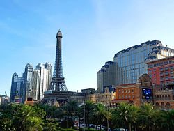
Cotai (Chinese: 路氹城; Cantonese Yale: Louhtáhm Sìhng; Portuguese: Cotai) is a 5.2-square-kilometer (2.0 sq mi) piece of reclaimed land on the top of the Seac Pai Bay between Taipa and Coloane islands in Macau[1] that has connected two independent islands since 2005. The name, which is a portmanteau of Coloane and Taipa, can also refer to the island formed by the reclaimation. In the second sense, the Special Administrative Region of Macau now consists of the Macau Peninsula, plus Cotai Island, about a mile to the south.[2]
Cotai was created to provide Macau with a new gambling and tourism area, since Macau is so densely populated and land is scarce. Many hotels and casinos can now be found on the island.[3] In 2006, a new hospital was founded in the Cotai area, the MUST Hospital, which is associated with the Macau University of Science and Technology Foundation.
- ^ Tan, Anthony (25 November 2006). "Must-see Macau". The Star. Retrieved 26 November 2021.
- ^ "Macao hoists Signal No. 9 to embrace Typhoon Mangkhut". Archived from the original on September 16, 2018. Retrieved 2018-12-23.
- ^ Starkweather, Maxim. "History of Cotai - The Creation of Cotai - Macau Casinos". Macau Casinos. Archived from the original on 2017-03-25. Retrieved 2017-03-24.
© MMXXIII Rich X Search. We shall prevail. All rights reserved. Rich X Search