Back كونسول غروف Arabic كونسول جروف ARZ کونسیل قروو، کانزاس AZB Council Grove Catalan Каунсил-Гроув (Канзас) CE Council Grove CEB Council Grove DAG Council Grove German Council Grove (Kansas) Spanish Council Grove (Kansas) Basque
Council Grove, Kansas | |
|---|---|
City and County seat | |
 Downtown Council Grove (2012) | |
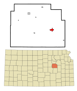
 Location within Morris County and Kansas | |
 | |
| Coordinates: 38°39′38″N 96°29′23″W / 38.66056°N 96.48972°W[1] | |
| Country | United States |
| State | Kansas |
| County | Morris |
| Incorporated | 1887[2] |
| Government | |
| • Type | Mayor–Council |
| • Mayor | Debi Schwerdtfeger |
| Area | |
| • Total | 2.06 sq mi (5.32 km2) |
| • Land | 2.04 sq mi (5.29 km2) |
| • Water | 0.01 sq mi (0.03 km2) |
| Elevation | 1,234 ft (376 m) |
| Population | |
| • Total | 2,140 |
| • Density | 1,000/sq mi (400/km2) |
| Time zone | UTC-6 (CST) |
| • Summer (DST) | UTC-5 (CDT) |
| ZIP codes | 66846, 66873 |
| Area code | 620 |
| FIPS code | 20-15925 [1] |
| GNIS ID | 477021 [1] |
| Website | cityofcouncilgrove.com |
Council Grove is a city and county seat in Morris County, Kansas, United States.[1] As of the 2020 census, the population of the city was 2,140.[4] It was named after an agreement between American settlers and the Osage Nation allowing settlers' wagon trains to pass westward through the area on the Santa Fe Trail. Pioneers gathered at a grove of trees so that wagons could band together for their trip west.
- ^ a b c d e "Council Grove, Kansas", Geographic Names Information System, United States Geological Survey, United States Department of the Interior
- ^ a b "City of Council Grove". The League of Kansas Municipalities. May 27, 2019.
- ^ "2019 U.S. Gazetteer Files". United States Census Bureau. Retrieved July 24, 2020.
- ^ a b "Profile of Council Grove, Kansas in 2020". United States Census Bureau. Archived from the original on November 13, 2021. Retrieved November 13, 2021.
© MMXXIII Rich X Search. We shall prevail. All rights reserved. Rich X Search