Back كوفنتري (كونيتيكت) Arabic بلده كوفنترى ARZ Coventry (Connecticut) Catalan Ковентри (Коннектикут) CE Coventry, Connecticut Welsh Coventry (Connecticut) German Coventry (Connecticut) Spanish Coventry (Connecticut) Basque Coventry (Connecticut) French Coventry, Connecticut HT
Coventry, Connecticut | |
|---|---|
| Town of Coventry | |
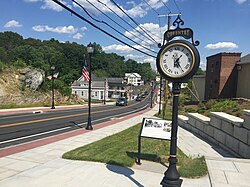
 The center of South Coventry, nearby Coventry Lake | |
| Coordinates: 41°47′04″N 72°20′20″W / 41.78444°N 72.33889°W | |
| Country | |
| U.S. state | |
| County | Tolland |
| Region | Capitol Region |
| Incorporated | 1712 |
| Government | |
| • Type | Council-Manager |
| • Town Manager | John A. Elsesser |
| • Town council | Lisa Thomas, Council Chair Marty Milkovic (D), Vice-Chair Jonathan Hand (D), Secretary Julie Blanchard (R) Robyn Gallagher (D) Mather Kyer (D) John French (R) |
| Area | |
| • Total | 38.4 sq mi (99.5 km2) |
| • Land | 37.7 sq mi (97.7 km2) |
| • Water | 0.6 sq mi (1.7 km2) |
| Elevation | 656 ft (200 m) |
| Population (2020) | |
| • Total | 12,235 |
| • Density | 324.5/sq mi (125.2/km2) |
| Time zone | UTC-5 (EST) |
| • Summer (DST) | UTC-4 (EDT) |
| ZIP Code | 06238 |
| Area code(s) | 860/959 |
| FIPS code | 09-17800 |
| GNIS feature ID | 0213413 |
| Website | www |
Coventry (/ˈkɑːvəntri/ CAH-vən-tree) is a town in Tolland County and in the Capitol Planning Region, Connecticut, United States. The population was 12,235 at the 2020 census.[1] The birthplace of Captain Nathan Hale, Coventry is home to the Nathan Hale Homestead, which is now a museum open to the public. Coventry was incorporated in May 1712.
- ^ "Census - Geography Profile: Coventry town, Tolland County, Connecticut". Retrieved November 27, 2021.
© MMXXIII Rich X Search. We shall prevail. All rights reserved. Rich X Search


