Back كوينغتون (أوهايو) Arabic Covington (Ohio) Catalan Covington (lungsod sa Tinipong Bansa, Ohio) CEB Covington, Ohio Welsh Covington (Ohio) Spanish Covington (Ohio) Basque کاوینگتون، اوهایو Persian Covington (Ohio) French Covington, Ohio HT Covington (Ohio) Italian
Covington, Ohio | |
|---|---|
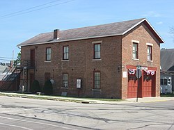
 Covington's old village hall, now a museum | |
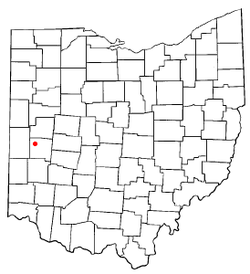
 Location of Covington, Ohio | |
 Detailed map of Covington | |
| Coordinates: 40°07′20″N 84°21′05″W / 40.12222°N 84.35139°W | |
| Country | United States |
| State | Ohio |
| County | Miami |
| Township | Newberry |
| Area | |
| • Total | 1.40 sq mi (3.62 km2) |
| • Land | 1.37 sq mi (3.55 km2) |
| • Water | 0.03 sq mi (0.07 km2) |
| Elevation | 929 ft (283 m) |
| Population (2020) | |
| • Total | 2,548 |
| • Estimate (2023)[3] | 2,598 |
| • Density | 1,858.50/sq mi (717.78/km2) |
| Time zone | UTC-5 (Eastern (EST)) |
| • Summer (DST) | UTC-4 (EDT) |
| ZIP code | 45318 |
| Area code(s) | 937, 326 |
| FIPS code | 39-19050[4] |
| GNIS feature ID | 2398638[2] |
Covington is a village in Miami County, Ohio, United States. The population was 2,548 at the 2020 census. It is part of the Dayton Metropolitan Statistical Area. The village was incorporated as Covington in 1835 on the site of the 1793 Fort Rowdy.
- ^ "ArcGIS REST Services Directory". United States Census Bureau. Retrieved September 20, 2022.
- ^ a b U.S. Geological Survey Geographic Names Information System: Covington, Ohio
- ^ "Annual Estimates of the Resident Population for Incorporated Places in Ohio: April 1, 2020 to July 1, 2023". United States Census Bureau. Retrieved June 14, 2024.
- ^ "U.S. Census website". United States Census Bureau. Retrieved January 31, 2008.
© MMXXIII Rich X Search. We shall prevail. All rights reserved. Rich X Search