Back مقاطعة كاولي (كانساس) Arabic کوولئی بؤلگهسی، کانزاس AZB Cowley County, Kansas BAR Каули (окръг, Канзас) Bulgarian কোৱলি কাউন্টি, ক্যানসাস BPY Cowley Gông (Kansas) CDO Каули (гуо, Канзас) CE Cowley County CEB Cowley County Czech Cowley County, Kansas Welsh
Cowley County | |
|---|---|
 | |
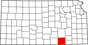
 Location within the U.S. state of Kansas | |
 Kansas's location within the U.S. | |
| Coordinates: 37°14′N 96°50′W / 37.233°N 96.833°W | |
| Country | |
| State | |
| Founded | February 26, 1867 |
| Named for | Matthew Cowley |
| Seat | Winfield |
| Largest city | Arkansas City |
| Area | |
| • Total | 1,132 sq mi (2,930 km2) |
| • Land | 1,126 sq mi (2,920 km2) |
| • Water | 6.7 sq mi (17 km2) 0.6% |
| Population | |
| • Total | 34,549 |
| • Density | 30.7/sq mi (11.9/km2) |
| Time zone | UTC−6 (Central) |
| • Summer (DST) | UTC−5 (CDT) |
| Area code | 620 |
| Congressional district | 4th |
| Website | cowleycounty.org |
Cowley County is a county located in the U.S. state of Kansas. Its county seat is Winfield,[2] and its most populous city is Arkansas City. As of the 2020 census, the county population was 34,549.[1] The county was named after Matthew Cowley, first lieutenant in Company I, 9th Kansas Cavalry, who died during the American Civil War.
- ^ a b "QuickFacts; Cowley County, Kansas; Population, Census, 2020 & 2010". United States Census Bureau. Archived from the original on August 16, 2021. Retrieved August 15, 2021.
- ^ "Find a County". National Association of Counties. Archived from the original on May 31, 2011. Retrieved June 7, 2011.
© MMXXIII Rich X Search. We shall prevail. All rights reserved. Rich X Search