Back مقاطعة كريتيندين (كنتاكي) Arabic Crittenden County, Kentucky BAR Критъндън (окръг, Кентъки) Bulgarian ক্রিটেনডেন কাউন্টি, কেন্টাকি BPY Crittenden Gông (Kentucky) CDO Криттенден (гуо, Кентукки) CE Crittenden County (kondado sa Tinipong Bansa, Kentucky) CEB Crittenden County (Kentucky) Czech Crittenden County, Kentucky Welsh Crittenden County (Kentucky) German
Crittenden County | |
|---|---|
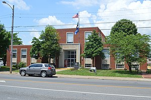
 Crittenden County Courthouse in Marion | |
 Location within the U.S. state of Kentucky | |
 Kentucky's location within the U.S. | |
| Coordinates: 37°22′N 88°05′W / 37.36°N 88.09°W | |
| Country | |
| State | |
| Founded | 1842 |
| Named for | John J. Crittenden |
| Seat | Marion |
| Largest city | Marion |
| Area | |
| • Total | 371 sq mi (960 km2) |
| • Land | 360 sq mi (900 km2) |
| • Water | 11 sq mi (30 km2) 3.0% |
| Population (2020) | |
| • Total | 8,990 |
| • Estimate (2023) | 8,974 |
| • Density | 24/sq mi (9.4/km2) |
| Time zone | UTC−6 (Central) |
| • Summer (DST) | UTC−5 (CDT) |
| Congressional district | 1st |
| Website | www |
Crittenden County is a county in the U.S. state of Kentucky. At the 2020 census, the population was 8,990.[1] Its county seat and only municipality is Marion.[2] The county was formed in 1842 and named for John J. Crittenden, senator and future Governor of Kentucky.[3][4]
- ^ "Census - Geography Profile: Crittenden County, Kentucky". United States Census Bureau. Retrieved December 30, 2022.
- ^ "Find a County". National Association of Counties. Archived from the original on May 31, 2011. Retrieved June 7, 2011.
- ^ The Register of the Kentucky State Historical Society, Volume 1. Kentucky State Historical Society. 1903. pp. 35.
- ^ Gannett, Henry (1905). The Origin of Certain Place Names in the United States. Govt. Print. Off. pp. 96.
© MMXXIII Rich X Search. We shall prevail. All rights reserved. Rich X Search