| Cuyama Valley | |
|---|---|
 Rugged terrain surrounding the Cuyama Valley | |
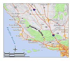
 Location of the Cuyama Valley in southern and central California: green areas are national forests and national parks | |
| Area | 300 square miles (780 km2) |
| Geography | |
| Location | California, United States |
| Population centers | Cuyama, New Cuyama, Ventucopa |
| Coordinates | 34°55′46″N 119°35′50″W / 34.9295°N 119.5971°W |
| Traversed by | State Route 166, State Route 33 |
| Rivers | Cuyama River |
The Cuyama Valley (Chumash: Kuyam, meaning "Clam")[1] is a valley along the Cuyama River in Central California, in northern Santa Barbara, southern San Luis Obispo, southwestern Kern, and northwestern Ventura counties. It is about two hours driving time from both Los Angeles and the Santa Barbara area.
It is a sparsely inhabited area containing two primary towns – Cuyama and New Cuyama, and also Ventucopa. The land is largely used for ranching, agriculture, and oil and gas production. California State Route 166 runs along most of the east/west length of the valley, connecting the Kern County and the southern San Joaquin Valley with Santa Maria and coastal Santa Barbara and San Luis Obispo Counties. State Route 33 runs north/south through the eastern end of the valley, connecting the southern San Joaquin Valley with Ojai and coastal Ventura County.
- ^ Bright, William; Erwin G. Gudde (1998). 1500 California Place Names: Their Origin and Meaning. University of California Press. p. 46. ISBN 0-520-21271-1.
© MMXXIII Rich X Search. We shall prevail. All rights reserved. Rich X Search
