Back দাগশাই Bengali/Bangla দাগশাই BPY Dagshai CEB Dagshai Cantonment Spanish डगशाई Hindi Dagshai Italian Dagshai Malay दागश्री NEW Dagshai Dutch Dagshai Polish
Dagshai
Dagshai & Kumarhatti | |
|---|---|
town | |
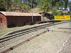
 Kumarhatti Dagshai Railway Station | |
| Coordinates: 30°53′N 77°03′E / 30.88°N 77.05°E | |
| Country | |
| State | Himachal Pradesh |
| District | Solan |
| Elevation | 1,734 m (5,689 ft) |
| Population (2011) | |
| • Total | 2,904 |
| Languages | |
| • Official | Hindi |
| Time zone | UTC+5:30 (IST) |
| Vehicle registration | HP |
Dagshai, also known as Daagh-e-Shahi, is one of the oldest cantonment towns in the Solan district of Himachal Pradesh, India. It is situated on top of a 5,689-foot (1,734-m) high hillock that stands sphinx-like astride the Kalka-Shimla Highway at a point about 11 km from Solan. It was founded in 1847 by the East India Company by securing free of cost five villages from Maharaja of Patiala aka Bhupinder Singh of Patiala. The names of these villages were Dabbi, Badhtiala, Chunawad, Jawag and Dagshai. The new cantonment was named after the last named village, as it was the largest and most strategically located. The name Dagshai, according to a popular local legend was derived from Daagh-e-Shahi. During the Moghul times a Daagh-e-Shahi (royal mark) was put on the forehead of the criminals and sent packing to the then Dagshai village.[citation needed]

- ^ From photo album of Private Robert Victor Soper, Hampshire Regiment; Titled "Our quarters, Dagshai; Kasouli Ridge behind, with Monkey Point 6,322ft"
© MMXXIII Rich X Search. We shall prevail. All rights reserved. Rich X Search

