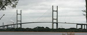
Dames Point Bridge | |
|---|---|
 Dames Point Bridge in 2010. | |
| Coordinates | 30°23′09″N 81°33′27″W / 30.3858°N 81.5574°W |
| Carries | (six general purpose lanes) |
| Crosses | St. Johns River |
| Locale | Jacksonville, Florida |
| Official name | Napoleon Bonaparte Broward Bridge |
| Maintained by | Florida Department of Transportation |
| ID number | 720518 |
| Characteristics | |
| Design | Continuous prestressed concrete cable-stayed bridge |
| Total length | 10,646 feet (3244.9 m) |
| Width | 106 feet (32.2 m) |
| Height | 471 feet (143.5 m) |
| Longest span | 1,300 feet (396.2 m) |
| Clearance above | 39.7 feet (12.11 m) |
| Clearance below | 175 feet (53.34 m) |
| History | |
| Construction start | 1985 |
| Opened | March 10, 1989 |
| Statistics | |
| Daily traffic | 77,000 (2019) |
| Location | |
 | |
The Dames Point Bridge (officially the Napoleon Bonaparte Broward Bridge) is a cable-stayed bridge over the St. Johns River in Jacksonville, Florida, United States on the Interstate 295 East Beltway. Construction began in 1985 and was completed in 1989. The main span is 1,300 feet (396.2 m), and is 175 feet (53.3 m) high. The bridge was designed by HNTB Corporation and RS&H, Inc. The Massman Construction Company built the bridge.[1]
- ^ Hannan, Larry (March 10, 2009). "Dames Point bridge reaches 20-year mark". The Florida Times-Union. Retrieved March 27, 2009.
© MMXXIII Rich X Search. We shall prevail. All rights reserved. Rich X Search
