Back دامودار Arabic نهر دامودار ARZ Damodar çayı Azerbaijani دامودار AZB Дамодар Byelorussian Дамодар (река) Bulgarian दामोदर नदी Bihari দামোদর নদ Bengali/Bangla Damodar Catalan Dāmodar River CEB
| Damodar River | |
|---|---|
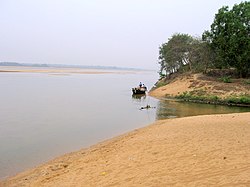
 Damodar River in the lower reaches of the Chota Nagpur Plateau in dry season | |
 Damodar Map | |
| Location | |
| Country | India |
| Location | Jharkhand, West Bengal |
| Physical characteristics | |
| Source | |
| • location | ChulhaPani, Latehar district, Chota Nagpur Plateau, Jharkhand |
| Mouth | |
• location | Hooghly River, Howrah district, West Bengal |
| Length | 592 km (368 mi) |
| Discharge | |
| • average | 296 m3/s (10,500 cu ft/s)[1] |
| Basin features | |
| Tributaries | |
| • left | Barakar, Konar, Jamunia, Nunia |
| • right | Sali River (West Bengal) |
Damodar River (Pron: /ˈdʌmoˌdaː/) is a river flowing across the Indian states of Jharkhand and West Bengal. The valley is rich in mineral resources and is known for large-scale mining and industrial activity. It was also known as the Sorrow of Bengal[2] because of the ravaging floods it caused in the plains of West Bengal. The construction of several dams on the Damodar and its tributaries has helped control some of the flooding.
- ^ Damodar Basin Station: Rhondia, UNH/GRDC
- ^ "River Damodar is called Sorrow of Bengal because it (A) Causes maximum soil erosion (B) Gets flooded often causing havoc (C) Forms number of dangerous waterfalls (D) is not a perennial river - Rediff Questions & Answers". Archived from the original on 2013-10-22. Retrieved 2013-10-22.
© MMXXIII Rich X Search. We shall prevail. All rights reserved. Rich X Search