Back দারকাদ জেলা Bengali/Bangla Darqad CEB ولسوالی درقد Persian District de Darqad French Distretto di Darqad Italian Daerah Darqad Malay درقد ولسوالۍ Pashto/Pushto Darqad Portuguese Darqad Swedish Darqad tumani Uzbek
Darqad District
درقد ولسوالۍ | |
|---|---|
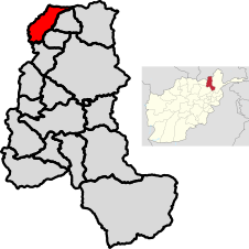
 Location of the district in Takhar Province | |
| Coordinates: 37°23′06″N 69°27′18″E / 37.385°N 69.455°E | |
| Country | |
| Province | Takhār Province |
| Seat | Darqad |
| Area | |
| • Total | 393 km2 (152 sq mi) |
| Population (2015)[2] | |
| • Total | 25,152 |
| • Density | 64/km2 (170/sq mi) |
| Time zone | UTC+4:30 (Afghanistan Standard Time) |
| Post code | 3758[3] |
Darqad District (Pashto: درقد ولسوالۍ) is a district of Takhar Province, Afghanistan. The district has 34 villages.[1] Darqad did not change between the 325 and 398 district sets.[4] Near the end of 2018, the district was considered to be Taliban-influenced, as opposed to the Afghan government.[5] The district was Taliban-controlled by August 2021.[6]
- ^ a b "Darqad English Summary Finalized" (PDF). mrrd-napdp.org. Ministry of Rural Rehabilitation and Development. June 2006. Archived from the original (PDF) on 3 March 2016. Retrieved 1 August 2020.
- ^ "Takhar Socio-Demographic Economic Survey" (PDF). afghanistan.unfpa.org. UNFPA. September 2015. Retrieved 1 August 2020.
- ^ "Darqad Post Codes: Afghanistan". worldpostalcode.com. Retrieved 1 August 2020.
- ^ "Story Map Series". mapsynch.maps.arcgis.com. Retrieved 3 August 2020.
- ^ "Quarterly Report to the United States Congress" (PDF). sigar.mil. 30 January 2019. p. 71. Retrieved 3 August 2020.
- ^ "Mapping the advance of the Taliban in Afghanistan". BBC News. 5 August 2021. Retrieved 5 August 2021.
© MMXXIII Rich X Search. We shall prevail. All rights reserved. Rich X Search