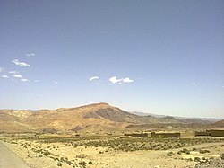
Datakhel
دته خېل | |
|---|---|
Town | |
 | |
| Coordinates: 32°54′18.4″N 69°44′56″E / 32.905111°N 69.74889°E | |
| Country | |
| Province | |
| District | North Waziristan |
| Tehsil | Datta Khel |
| Elevation | 2,010 m (6,590 ft) |
| Population | |
| • Total | 1,037 |
| Time zone | UTC+5 (PST) |
Datakhel (Pashto: دته خېل) or Datta Khel is a town in North Waziristan district of Khyber Pakhtunkhwa, Pakistan.[2][3][4]
It is part of Datta Khel Tehsil of North Waziristan district.[5]
- ^ "POPULATION AND HOUSEHOLD DETAIL FROM BLOCK TO DISTRICT LEVEL: FATA (NORTH WAZIRISTAN)" (PDF). www.pbscensus.gov.pk. 2018-01-03. Archived from the original (PDF) on 2018-04-03. Retrieved 2018-04-02.
- ^ "President signs amendment bill, merging FATA with KP". Geo News. Archived from the original on 2018-06-15. Retrieved 2018-06-26.
- ^ Dawn.com, Amir Wasim (2018-05-24). "National Assembly green-lights Fata-KP merger by passing 'historic' bill". DAWN.COM. Archived from the original on 2018-06-18. Retrieved 2018-06-26.
- ^ Farooq, Umar (2017-12-06). "In Pakistan's Tribal Areas, Collective Punishment Is the Law of the Land". The Nation. ISSN 0027-8378. Archived from the original on 2018-06-26. Retrieved 2018-06-26.
- ^ "DISTRICT AND TEHSIL LEVEL POPULATION SUMMARY WITH REGION BREAKUP - North Waziristan" (PDF). www.pbscensus.gov.pk. Archived from the original (PDF) on 2018-06-27. Retrieved 2018-06-26.
© MMXXIII Rich X Search. We shall prevail. All rights reserved. Rich X Search
