Back Dawes Point (bahin nga lungsod) CEB داز پوینت، نیو ساوت ولز Persian דוז פוינט HE Dawes Point Polish Dawes Point, New South Wales Romanian Dawes Point Swedish ڈوز پوائنٹ، نیو ساؤتھ ویلز Urdu
| Dawes Point Sydney, New South Wales | |||||||||||||||
|---|---|---|---|---|---|---|---|---|---|---|---|---|---|---|---|
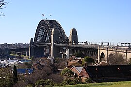
 Sydney Harbour Bridge, viewed from Observatory Hill | |||||||||||||||
 | |||||||||||||||
| Coordinates | 33°51′22″S 151°12′25″E / 33.856°S 151.207°E | ||||||||||||||
| Population | 385 (SAL 2021)[1] | ||||||||||||||
| Postcode(s) | 2000 | ||||||||||||||
| Area | 0.1 km2 (0.0 sq mi) | ||||||||||||||
| Location | 1 km (1 mi) north of Sydney CBD | ||||||||||||||
| LGA(s) | City of Sydney | ||||||||||||||
| Parish | St. Philip | ||||||||||||||
| State electorate(s) | Sydney | ||||||||||||||
| Federal division(s) | Sydney | ||||||||||||||
| |||||||||||||||
Dawes Point is a suburb of the City of Sydney, in the state of New South Wales, Australia. Dawes Point is located on the north-western edge of the Sydney central business district, at the southern end of Sydney Harbour Bridge, adjacent to The Rocks. At times Dawes Point has been considered to be part of The Rocks, or known as West Rocks, part of Millers Point, or part of it known as Walsh Bay.
- ^ Australian Bureau of Statistics (28 June 2022). "Dawes Point (suburb and locality)". Australian Census 2021 QuickStats. Retrieved 28 June 2022.
© MMXXIII Rich X Search. We shall prevail. All rights reserved. Rich X Search
