Back جزيرة ديسيتشيو Arabic Desecheo Breton Illa Desecheo Catalan Isla Desecheo CEB Desecheo German Isla Desecheo Spanish Desecheo Estonian Desecheo uhartea Basque Desecheo French Desecheo Italian
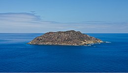
 Isla Desecheo, oblique aerial photograph | |
 | |
| Geography | |
|---|---|
| Coordinates | 18°23′14″N 67°28′19″W / 18.38722°N 67.47194°W |
| Area | 1.524613 km2 (0.588656 sq mi) |
| Length | 1.8 km (1.12 mi) |
| Width | 1.1 km (0.68 mi) |
| Highest elevation | 218 m (715 ft) |
| Highest point | Sego Can Ridge |
| Administration | |
| Commonwealth | Puerto Rico |
| Municipio | Mayagüez |
| Barrio | Sabanetas |


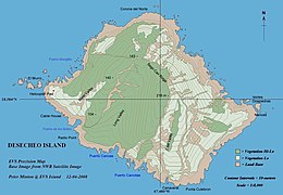
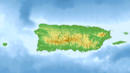
Desecheo (Spanish: Isla Desecheo) (Spanish pronunciation: [deseˈtʃeo]) is a small uninhabited island of the archipelago of Puerto Rico in the northeast of the Mona Passage; 13 mi (21 km) from Rincón on the west coast (Punta Higüero) of the main island of Puerto Rico and 31 mi (50 km) northeast of Mona Island. It has a land area of 0.589 sq mi (377 acres; 153 ha; 1.53 km2). Politically, the island is administered by the U.S. Department of the Interior, U.S. Fish and Wildlife Service as the Desecheo National Wildlife Refuge, but part of the Sabanetas barrio of Mayagüez.
© MMXXIII Rich X Search. We shall prevail. All rights reserved. Rich X Search


