36°24′06″N 81°10′15″W / 36.401803°N 81.170797°W

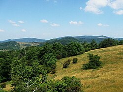
Doughton Park (Doughton Recreational Area) is the largest recreation area the National Park Service manages on the Blue Ridge Parkway. It is located between mile markers 238.5 - 244.7[1] on the border between Wilkes and Alleghany Counties in North Carolina. Doughton Park consists of highland meadows with numerous scenic overlooks, miles of hiking and bridle trails, areas for camping and cookouts, and it is one of the few areas on the Parkway that has a restaurant (called The Bluffs) along with an adjacent visitors center maintained by the National Park Service.[2] Elevations in Doughton Park generally range from 3,500 to 4,000 feet (1,100 to 1,200 m).[3] The park is named after North Carolina politician Robert L. Doughton, who lived in nearby Laurel Springs, North Carolina and who as a US Congressman played a key role in the creation of the Blue Ridge Parkway in the 1930s.[4]
© MMXXIII Rich X Search. We shall prevail. All rights reserved. Rich X Search
