Back دوغلاس (ماساتشوستس) Arabic بلده دوجلاس, الولايات المتحدة ARZ دوقلاس، ماساچوست AZB Douglas (Massachusetts) Catalan Дуглас (Массачусетс) CE Douglas (lungsod sa Tinipong Bansa, Massachusetts) CEB Douglas, Massachusetts Welsh Douglas (Massachusetts) Spanish Douglas (Massachusetts) Basque داگلاس، ماساچوست Persian
Douglas, Massachusetts | |
|---|---|
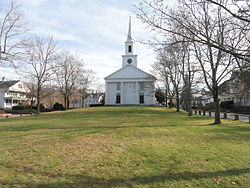
 Second Congregational Church | |
| Nicknames: D-town, The Big D | |
 Location in Worcester County and the state of Massachusetts. | |
| Coordinates: 42°03′15″N 71°44′24″W / 42.05417°N 71.74000°W | |
| Country | United States |
| State | Massachusetts |
| County | Worcester |
| Settled | 1721 |
| Incorporated | 1746 |
| Government | |
| • Type | Open town meeting |
| Area | |
| • Total | 37.7 sq mi (97.7 km2) |
| • Land | 36.4 sq mi (94.2 km2) |
| • Water | 1.3 sq mi (3.5 km2) |
| Elevation | 582 ft (177 m) |
| Population (2020) | |
| • Total | 768 |
| • Density | 20/sq mi (7.9/km2) |
| Time zone | UTC-5 (Eastern) |
| • Summer (DST) | UTC-4 (Eastern) |
| ZIP code | 01516 |
| Area code | 508 / 774 |
| FIPS code | 25-17300 |
| GNIS feature ID | 0619479 |
| Website | www www |
Douglas is a town in southern Worcester County, Massachusetts, United States. The population was 8,983 at the 2020 census.[1] It includes the Douglas State Forest, managed by the Department of Conservation and Recreation (DCR).
- ^ "Census - Geography Profile: Douglas town, Worcester County, Massachusetts". United States Census Bureau. Retrieved November 11, 2021.
© MMXXIII Rich X Search. We shall prevail. All rights reserved. Rich X Search

