Back Douro (comunidá intermunicipal) AST Subregió del Douro Catalan Douro (Subregion) German Duero (comunidad intermunicipal) Spanish Duero (azpieskualdea) Basque Douron alue Finnish Douro (sous-région) French Subrexión de Douro Galician Douro (subregione) Italian Douro (zespół miejski) Polish
Douro | |
|---|---|
 | |
| Coordinates: 41°18′N 7°45′W / 41.300°N 7.750°W | |
| Country | |
| Region | Norte |
| Seat | Vila Real |
| Municipalities | 19 |
| Area | |
| • Total | 4,031.58 km2 (1,556.60 sq mi) |
| Population (2011) | |
| • Total | 205,157 |
| • Density | 51/km2 (130/sq mi) |
| Time zone | UTC±00:00 (WET) |
| • Summer (DST) | UTC+01:00 (WEST) |
| Website | cimdouro |
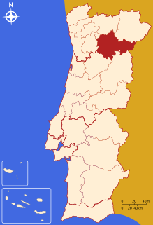
The Comunidade Intermunicipal do Douro (Portuguese pronunciation: [ˈdoɾu]) is an administrative division in Portugal. It replaced the Comunidade Urbana do Douro, created in 2004.[1] It takes its name from the Douro River. The seat of the intermunicipal community is Vila Real. Douro comprises parts of the former districts of Bragança, Guarda, Vila Real and Viseu. The population in 2011 was 205,157,[2] in an area of 4,031.58 square kilometres (1,556.60 sq mi).[3]
Douro is also a NUTS3 subregion of Norte Region. Since January 2015, the NUTS 3 subregion covers the same area as the intermunicipal community.[4]
Its economic activity is largely centered on the production of wine, particularly port, and also non-fortified Douro wine from the Douro DOC wine region. The entire region is mountainous and crossed by steep valleys.
- ^ CM Vila Nova de Foz Côa
- ^ Instituto Nacional de Estatística
- ^ "Áreas das freguesias, concelhos, distritos e país". Archived from the original on 2018-11-05. Retrieved 2018-11-05.
- ^ Adequação dos indicadores à nova organização territorial NUTS III / Entidades Intermunicipais, Instituto Nacional de Estatística, 18 March 2015
© MMXXIII Rich X Search. We shall prevail. All rights reserved. Rich X Search