Back مطار دوبيوك الإقليمي Arabic مطار دوبوك الاقليمى ARZ Dubuque Regional Airport CEB Dubuque Regional Airport German فرودگاه منطقهای دبیوک Persian Aeroportul Regional Dubuque Romanian Фурудгоҳи мантақаий дбюк Tajik ڈوبیوک ریجنل ہوائی اڈا Urdu
Dubuque Regional Airport | |||||||||||||||
|---|---|---|---|---|---|---|---|---|---|---|---|---|---|---|---|
 | |||||||||||||||
| Summary | |||||||||||||||
| Airport type | Public | ||||||||||||||
| Owner/Operator | City of Dubuque | ||||||||||||||
| Serves | Dubuque, Iowa | ||||||||||||||
| Elevation AMSL | 1,077 ft / 328 m | ||||||||||||||
| Coordinates | 42°24′07″N 090°42′34″W / 42.40194°N 90.70944°W | ||||||||||||||
| Website | www.FlyDBQ.com | ||||||||||||||
| Maps | |||||||||||||||
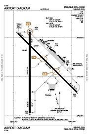 FAA airport diagram | |||||||||||||||
 | |||||||||||||||
| Runways | |||||||||||||||
| |||||||||||||||
| Statistics | |||||||||||||||
| |||||||||||||||
Dubuque Regional Airport (IATA: DBQ, ICAO: KDBQ, FAA LID: DBQ) is a regional airport located eight miles south of Dubuque, in Dubuque County, Iowa.[1] On U.S. Highway 61, the airport is owned by the city of Dubuque and is operated as a department of the city government. The city council appoints people for four-year terms to the Airport Commission board, which oversees the airport. For day-to-day operations, the Commission hires an airport manager. DBQ is used for general aviation and sees one airline. A charter service is run by Sun Country Airlines. The airport offers maintenance and refueling services, including service for jets.
The National Plan of Integrated Airport Systems for 2017–2021 categorized it as a primary commercial service facility.[2] Federal Aviation Administration records say the airport had 42,870 passenger boardings (enplanements) in calendar year 2008,[3] 39,359 in 2009, and 33,861 in 2010.[4]
- ^ a b FAA Airport Form 5010 for DBQ PDF. Federal Aviation Administration. effective July 13, 2023.
- ^ "2011–2015 NPIAS Report, Appendix A" (PDF). faa.gov. Federal Aviation Administration. October 4, 2010. Archived from the original (PDF, 2.03 MB) on 2012-09-27.
- ^ "Enplanements for CY 2008" (PDF, 1.0 MB). faa.gov. Federal Aviation Administration. December 18, 2009.
- ^ "Enplanements for CY 2010" (PDF, 189 KB). faa.gov. Federal Aviation Administration. October 4, 2011.
© MMXXIII Rich X Search. We shall prevail. All rights reserved. Rich X Search