| Dumanquilas Bay | |
|---|---|
| Dumanguilas Bay | |
 | |
| Location | Zamboanga Peninsula, Mindanao, Philippines |
| Coordinates | 7°40′22″N 123°05′46″E / 7.67278°N 123.09611°E |
| Type | bay |
| Part of | Moro Gulf |
| Islands | Igat Island + 12 smaller islands |
| Settlements | |
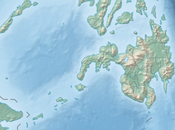
Dumanquilas Bay (alternatively spelled Dumanguilas Bay) is an arm of the Moro Gulf on the southern side of the Zamboanga Peninsula in western Mindanao island in the Philippines. It is shared between the provinces of Zamboanga del Sur on the eastern and northern shore, and Zamboanga Sibugay on the western shore. An irregularly shaped peninsula extending to Flecha Point separates it from Pagadian Bay to the east, while to the west, the bay connects with Sibuguey Bay through Canalizo Strait which separates Olutanga island from the mainland of Zamboanga. Politically, it is divided between the Zamboanga del Sur municipalities of Margosatubig, Vincenzo Sagun, Lapuyan and Kumalarang, and the Zamboangay Sibugay municipalities of Buug, Malangas and Alicia.
The bay is the location of the Malangas Wharf, the shipping point for the Malangas Coal Reservation. It is known for its extensive mangrove shorelines and rich coral and fish diversity.[1] It has been declared a marine protected area known as the Dumanquilas Bay Protected Landscape and Seascape in 1999.[2]
- ^ Manaytay, Antonio M. (3 December 2007). ""Let's talk coastal resource management" in bay cruise". MindaNews. Retrieved 26 October 2015.
- ^ "Proclamation No. 158, s. 1999". Official Gazette of the Republic of the Philippines. Retrieved 26 October 2015.
© MMXXIII Rich X Search. We shall prevail. All rights reserved. Rich X Search


