Back دور شروكين Arabic دور شروكين ARZ Dur-Şarrukin Azerbaijani Дур-Шаррукин Bashkir Дур-Шарукін Byelorussian Дур Шарукин Bulgarian দুর শাররুকিন Bengali/Bangla Dur Xarrukin Catalan دوورشاروکین CKB Chorsábád Czech
You can help expand this article with text translated from the corresponding article in French. Click [show] for important translation instructions.
|
ܕܘܪ ܫܪܘ ܘܟܢ (in Syriac) دور شروكين (in Arabic) | |
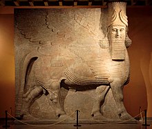
 A human-headed winged bull known as a lamassu from Dur-Sharrukin. Neo-Assyrian Period, ca. 721–705 BC | |
| Alternative name | Khorsabad |
|---|---|
| Location | Khorsabad, Nineveh Governorate, Iraq |
| Region | Mesopotamia |
| Coordinates | 36°30′34″N 43°13′46″E / 36.50944°N 43.22944°E |
| Type | Settlement |
| Length | 1,760 m (5,770 ft) |
| Width | 1,635 m (5,364 ft) |
| Area | 2.88 km2 (1.11 sq mi) |
| History | |
| Founded | In the decade preceding 706 BC |
| Abandoned | Approximately 605 BC |
| Periods | Neo-Assyrian Empire |
| Cultures | Assyrian |
| Site notes | |
| Excavation dates | 1842–1844, 1852–1855 1928–1935, 1957 |
| Archaeologists | Paul-Émile Botta, Eugène Flandin, Victor Place, Edward Chiera, Gordon Loud, Hamilton Darby, Fuad Safar |
| Condition | Severely Damaged |
| Public access | Inaccessible |
Dur-Sharrukin (Neo-Assyrian Akkadian: 𒂦𒈗𒁺, romanized: Dūr Šarru-kīn, "Fortress of Sargon"; Arabic: دور شروكين, Syriac: ܕܘܪ ܫܪܘ ܘܟܢ), present day Khorsabad, was the Assyrian capital in the time of Sargon II of Assyria. Khorsabad is a village in northern Iraq, 15 km northeast of Mosul. The great city was entirely built in the decade preceding 706 BC. After the unexpected death of Sargon in battle, the capital was shifted 20 km south to Nineveh.
© MMXXIII Rich X Search. We shall prevail. All rights reserved. Rich X Search
