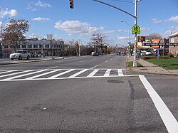
East Elmhurst | |
|---|---|
 Astoria Boulevard, a wide boulevard that serves East Elmhurst | |
 Location within New York City Note: red area overlaps with Jackson Heights. | |
| Coordinates: 40°45′40″N 73°51′54″W / 40.761°N 73.865°W | |
| Country | |
| State | |
| City | |
| Borough | |
| Community District | Queens 3[1] |
| Area | |
| • Total | 1.795 km2 (0.693 sq mi) |
| Population | |
| • Total | 23,150 |
| • Density | 13,000/km2 (33,000/sq mi) |
| Race/Ethnicity | |
| • Hispanic | 63.5% |
| • Black | 25.4% |
| • White | 4.7% |
| • Asian | 4.4% |
| • Other/Multiracial | 2.1% |
| Time zone | UTC−5 (EST) |
| • Summer (DST) | UTC−4 (EDT) |
| ZIP Code | 11369, 11370, 11371 |
| Area codes | 718, 347, 929, and 917 |
East Elmhurst is a residential neighborhood in the northwest section of the New York City borough of Queens. It is bounded to the south by Jackson Heights and Corona, to the north and east by Bowery Bay, and to the west by Woodside and Ditmars Steinway. The area also includes LaGuardia Airport, located on the shore of Flushing Bay, LaGuardia Landing Lights Fields, and Astoria Heights (the latter two in ZIP Code 11370).
East Elmhurst is part of Queens Community District 3 and its ZIP Codes are 11369, 11370, and 11371.[1] The neighborhood is patrolled by the New York City Police Department's 115th Precinct,[4] though the airport is patrolled by the Port Authority Police Department. East Elmhurst and its southern neighbor Corona are often referred to jointly as "Corona/East Elmhurst".
- ^ a b "NYC Planning | Community Profiles". communityprofiles.planning.nyc.gov. New York City Department of City Planning. Retrieved April 7, 2018.
- ^ Cite error: The named reference
PLP5was invoked but never defined (see the help page). - ^ Cite error: The named reference
PLP3Awas invoked but never defined (see the help page). - ^ "NYPD – 115th Precinct". www.nyc.gov. New York City Police Department. Retrieved October 3, 2016.
© MMXXIII Rich X Search. We shall prevail. All rights reserved. Rich X Search
