Back East Woodhay CEB East Woodhay Welsh وودهی شرقی Persian East Woodhay French East Woodhay Italian East Woodhay LLD East Woodhay Polish East Woodhay Swedish
| East Woodhay | |
|---|---|
 East Woodhay | |
Location within Hampshire | |
| Population | 2,914 (2011 Census, including Gore End)[1] |
| OS grid reference | SU407614 |
| Civil parish |
|
| District | |
| Shire county | |
| Region | |
| Country | England |
| Sovereign state | United Kingdom |
| Post town | NEWBURY |
| Postcode district | RG20 |
| Dialling code | 01635 |
| Police | Hampshire and Isle of Wight |
| Fire | Hampshire and Isle of Wight |
| Ambulance | South Central |
| UK Parliament | |
| Website | Parish Council |
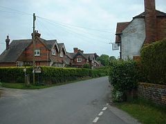
East Woodhay is a village and civil parish in Hampshire, England. The village is approximately 5.5 miles (9 km) south-west of Newbury in Berkshire. At the 2011 census the parish had a population of 2,914.

The parish contains a number of villages and hamlets, including Ball Hill, Heath End, Hatt Common, Woolton Hill and East End. The last two have schools: Woolton Hill Junior School, St Thomas's Church of England Infant School, and St. Martin's Church of England Primary School. The parish has a small, triangular village green which has a war memorial and was once the site of the village stocks. Woolton Hill has a village shop and post office, and "The Chase", a wooded area administered by the National Trust.
The summit of Pilot Hill, the highest point in the county of Hampshire, lies within the parish.[2]

- ^ "Civil Parish population 2011". Neighbourhood Statistics. Office for National Statistics. Retrieved 15 December 2016.
- ^ Explorer 158: Newbury & Hungerford (Map). Ordnance Survey. ISBN 9780319243510.
© MMXXIII Rich X Search. We shall prevail. All rights reserved. Rich X Search
