Back ال پورتال، کالیفورنیا AZB Ель-Портал (Калифорни) CE El Portal (lungsod sa Tinipong Bansa, California) CEB El Portal (Kalifornien) German El Portal (California) Spanish El Portal (Kalifornia) Basque ال پورتال، کالیفرنیا Persian El Portal (Californie) French El Portal (Kalifornija) Croatian El Portal (California) Italian
El Portal | |
|---|---|
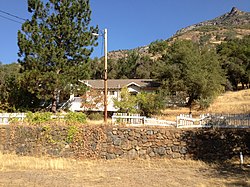
 The Old El Portal Schoolhouse | |
 Location in Mariposa County, California | |
| Coordinates: 37°40′29″N 119°47′03″W / 37.67472°N 119.78417°W | |
| Country | |
| State | |
| County | Mariposa |
| Area | |
| • Total | 1.910 sq mi (4.95 km2) |
| • Land | 1.864 sq mi (4.83 km2) |
| • Water | 0.046 sq mi (0.12 km2) 2.41% |
| Elevation | 1,939 ft (591 m) |
| Population (2020[3]) | |
| • Total | 372 |
| • Density | 199.6/sq mi (77.1/km2) |
| Time zone | UTC-8 (Pacific (PST)) |
| • Summer (DST) | UTC-7 (PDT) |
| ZIP Code | 95318 |
| GNIS feature IDs | U.S. Geological Survey Geographic Names Information System: El Portal, California U.S. Geological Survey Geographic Names Information System: El Portal, California |
| FIPS code | 06-22328 |
El Portal (Spanish for "The Gateway") is a census-designated place[4] in Mariposa County, California, United States.[2] It is located 11.5 miles (19 km) west-southwest of Yosemite Village,[5] at an elevation of 1,939 feet (591 m).[2] The population was 372 at the 2020 census,[3] down from 474 at the 2010 census.
- ^ "2021 U.S. Gazetteer Files: California". United States Census Bureau. Retrieved July 15, 2022.
- ^ a b c U.S. Geological Survey Geographic Names Information System: El Portal, California
- ^ a b "P1. Race – El Portal CDP, California: 2020 DEC Redistricting Data (PL 94-171)". U.S. Census Bureau. Retrieved July 15, 2022.
- ^ U.S. Geological Survey Geographic Names Information System: El Portal, California
- ^ Durham, David L. (1998). California's Geographic Names: A Gazetteer of Historic and Modern Names of the State. Clovis, Calif.: Word Dancer Press. p. 770. ISBN 1-884995-14-4.
© MMXXIII Rich X Search. We shall prevail. All rights reserved. Rich X Search
