| Cootamundra New South Wales—Legislative Assembly | |||||||||||||||
|---|---|---|---|---|---|---|---|---|---|---|---|---|---|---|---|
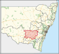
Interactive map of district boundaries from the 2023 state election | |||||||||||||||
| State | New South Wales | ||||||||||||||
| Dates current | 1904–1941 2015–present | ||||||||||||||
| MP | Steph Cooke | ||||||||||||||
| Party | National Party | ||||||||||||||
| Namesake | Cootamundra, New South Wales | ||||||||||||||
| Electors | 56,191 (2022) | ||||||||||||||
| Area | 34,711.35 km2 (13,402.1 sq mi) | ||||||||||||||
| Demographic | Rural | ||||||||||||||
| |||||||||||||||
Cootamundra is an electoral district of the Legislative Assembly in the Australian state of New South Wales.
Cootamundra is a regional electorate encompassing the local government areas of Bland Shire, Narrandera Shire, Coolamon Shire, Temora Shire, Junee Shire, Weddin Shire, Cowra Shire, part of Hilltops Council and Cootamundra-Gundagai Regional Council.[1]
- ^ "Cootamundra". New South Wales Electoral Commission. Retrieved 23 November 2019.
© MMXXIII Rich X Search. We shall prevail. All rights reserved. Rich X Search


