| Mulgrave Queensland—Legislative Assembly | |||||||||||||||
|---|---|---|---|---|---|---|---|---|---|---|---|---|---|---|---|
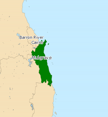
 Electoral map of Mulgrave 2017 | |||||||||||||||
| State | Queensland | ||||||||||||||
| Dates current | 1873–1888; 1950–present | ||||||||||||||
| MP | Curtis Pitt | ||||||||||||||
| Party | Labor | ||||||||||||||
| Namesake | Mulgrave River | ||||||||||||||
| Electors | 35,635 (2020) | ||||||||||||||
| Area | 819 km2 (316.2 sq mi) | ||||||||||||||
| Demographic | Provincial and rural | ||||||||||||||
| Coordinates | 17°13′S 145°51′E / 17.217°S 145.850°E | ||||||||||||||
| |||||||||||||||

Mulgrave is an electoral district of the Legislative Assembly in the Australian state of Queensland.
The district in its present form is a narrow coastal strip running from the southern suburbs of Cairns at its northern end to Innisfail at its southern end. Mulgrave also includes the towns of Gordonvale and Babinda. The electorate was first created for the 1950 election.
There was an earlier district also called Mulgrave that existed from 1873 to 1888. It was based on the town of Bundaberg and was replaced by the new electoral district of Bundaberg by the Electoral Districts Act of 1887.[1]
In 2017 a chunk of the electoral district split from Mulgrave, this area includes Innisfail, Tully and Babinda districts.
- ^ "Representatives of Queensland State Electorates 1860-2017" (PDF). Queensland Parliamentary Record 2012-2017: The 55th Parliament. Queensland Parliament. Archived from the original (PDF) on 27 April 2020. Retrieved 27 April 2020.
© MMXXIII Rich X Search. We shall prevail. All rights reserved. Rich X Search
