| Springwood Queensland—Legislative Assembly | |||||||||||||||
|---|---|---|---|---|---|---|---|---|---|---|---|---|---|---|---|
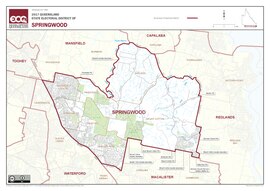 Electoral map of Springwood 2017 | |||||||||||||||
| State | Queensland | ||||||||||||||
| Dates current | 1986–present | ||||||||||||||
| MP | Mick de Brenni | ||||||||||||||
| Party | Labor | ||||||||||||||
| Namesake | Springwood | ||||||||||||||
| Electors | 35,376 (2020) | ||||||||||||||
| Area | 99 km2 (38.2 sq mi) | ||||||||||||||
| Demographic | Outer-metropolitan | ||||||||||||||
| Coordinates | 27°39′S 153°10′E / 27.650°S 153.167°E | ||||||||||||||
| |||||||||||||||

Springwood is an electoral district of the Legislative Assembly in the Australian state of Queensland.[1]
The district is based in several suburbs of Logan City. It is named after the suburb of Springwood and also includes the suburbs of Daisy Hill, Loganholme, Rochedale South and Shailer Park. The electorate was first contested in 1986.
- ^ "Representatives of Queensland State Electorates 1860-2017" (PDF). Queensland Parliamentary Record 2012-2017: The 55th Parliament. Queensland Parliament. Archived from the original (PDF) on 27 April 2020.
© MMXXIII Rich X Search. We shall prevail. All rights reserved. Rich X Search