| Warrego Queensland—Legislative Assembly | |||||||||||||||
|---|---|---|---|---|---|---|---|---|---|---|---|---|---|---|---|
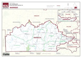 Electoral map of Warrego 2017 | |||||||||||||||
| State | Queensland | ||||||||||||||
| Created | 1865 | ||||||||||||||
| MP | Ann Leahy | ||||||||||||||
| Party | Liberal National | ||||||||||||||
| Namesake | Warrego River | ||||||||||||||
| Electors | 29,307 (2020) | ||||||||||||||
| Area | 337,812 km2 (130,429.9 sq mi) | ||||||||||||||
| Demographic | Rural | ||||||||||||||
| Coordinates | 26°52′S 146°9′E / 26.867°S 146.150°E | ||||||||||||||
| |||||||||||||||

Warrego is an electoral district of the Legislative Assembly in the Australian state of Queensland.
The electorate lies in the extreme southwest of Queensland, running along the western part of the border with New South Wales. It includes the large town of Dalby, as well as the rural centres of Surat, Roma, Tara, Charleville, Augathella, St George and Cunnamulla.
© MMXXIII Rich X Search. We shall prevail. All rights reserved. Rich X Search