| Englorie Park Sydney, New South Wales | |||||||||||||||
|---|---|---|---|---|---|---|---|---|---|---|---|---|---|---|---|
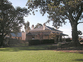
 Englorie Park House | |||||||||||||||
 | |||||||||||||||
| Population | 416 (2016 census)[1] | ||||||||||||||
| • Density | 3,703/km2 (9,590/sq mi) | ||||||||||||||
| Established | 2000 | ||||||||||||||
| Postcode(s) | 2560 | ||||||||||||||
| Elevation | 112 m (367 ft) | ||||||||||||||
| Area | 0.11235 km2 (0.0 sq mi) | ||||||||||||||
| Location | 55 km (34 mi) south-west of Sydney | ||||||||||||||
| LGA(s) | City of Campbelltown | ||||||||||||||
| State electorate(s) | Campbelltown | ||||||||||||||
| Federal division(s) | Macarthur | ||||||||||||||
| |||||||||||||||
Englorie Park is a suburb of Sydney, in the state of New South Wales, Australia. Englorie Park is located 55 kilometres south-west of the Sydney central business district, in the local government area of the City of Campbelltown and is part of the Macarthur region.
Englorie Park is the smallest suburb in NSW,[2] situated between the suburbs of Ambarvale, Campbelltown and Glen Alpine.[3] The suburb is almost entirely residential, except for a childcare centre that operates within the historic Englorie Park House. The majority of housing within the suburb is detached, with a minority of townhouses. Englorie Park is situated very close to the Macarthur Square shopping centre and Campbelltown Hospital.
- ^ Australian Bureau of Statistics (27 June 2017). "Englorie Park (State Suburb)". 2016 Census QuickStats. Retrieved 20 January 2019.
 Material was copied from this source, which is available under a Creative Commons Attribution 4.0 International License.
- ^ "PSMA 2018".
- ^ UBD Sydney Street Directory, Universal Publishing, 2007
© MMXXIII Rich X Search. We shall prevail. All rights reserved. Rich X Search
