Back أونترلاك (كيبك) Arabic Entrelacs CEB Entrelacs (Quebec) Spanish Entrelacs (Quebec) Basque آنترلاک، کبک Persian Entrelacs (Québec) French Entrelacs Swedish
Entrelacs | |
|---|---|
 | |
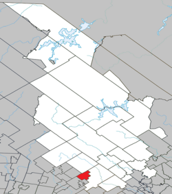
 Location within Matawinie RCM | |
| Coordinates: 46°07′N 74°00′W / 46.12°N 74°W[1] | |
| Country | Canada |
| Province | Quebec |
| Region | Lanaudière |
| RCM | Matawinie |
| Settled | 1840 |
| Constituted | January 1, 1860 |
| Government | |
| • Mayor | Sylvain Breton |
| • Federal riding | Joliette |
| • Prov. riding | Bertrand |
| Area | |
| • Total | 56.40 km2 (21.78 sq mi) |
| • Land | 48.71 km2 (18.81 sq mi) |
| Population (2021)[3] | |
| • Total | 1,054 |
| • Density | 21.6/km2 (56/sq mi) |
| • Pop 2016-2021 | |
| • Dwellings | 1,131 |
| Time zone | UTC−5 (EST) |
| • Summer (DST) | UTC−4 (EDT) |
| Postal code(s) | |
| Area code(s) | 450 and 579 |
| Highways | |
| Website | www |
Entrelacs is a municipality in Matawinie Regional County Municipality in the Lanaudière region of Quebec, Canada.
Prior to February 13, 1991, it was in Les Pays-d'en-Haut Regional County Municipality in the Laurentides region.[4]
- ^ Cite error: The named reference
toponymiewas invoked but never defined (see the help page). - ^ a b Cite error: The named reference
mamrotwas invoked but never defined (see the help page). - ^ a b Statistics Canada 2021 Census - Entrelacs census profile
- ^ "Archived copy" (PDF). Archived from the original (PDF) on 2012-04-18. Retrieved 2012-05-18.
{{cite web}}: CS1 maint: archived copy as title (link)
© MMXXIII Rich X Search. We shall prevail. All rights reserved. Rich X Search
