Back إنوغو Arabic انوجو ARZ انوقو AZB Енугу Bulgarian Enugu (ciutat) Catalan Enugu Czech Enugu Danish Enugu (Nigeria) German Enugu Esperanto Enugu Spanish
Enugu
Énugwú | |
|---|---|
City | |
 | |
| Nicknames: | |
| Coordinates: 6°27′10″N 7°30′40″E / 6.45278°N 7.51111°E | |
| Country | Nigeria |
| State | Enugu |
| LGA | Enugu East, Enugu North, Enugu South |
| Incorporated | in 1909 |
| Founded by | Enugwu-Ngwo and Ogui Nike people |
| Named for | its hilly geography |
| Government | |
| • Type | Executive Chairman-Council |
| • Governing body | Local Government Council |
| • Party | PDP |
| • Chairman | Azike Brian (Enugu North); Paul Ogbe (Enugu South Urban); Theresa Egbo (Enugu South Rural); Christopher Ugwu (Enugu East) |
| Area | |
| • Total | 556 km2 (215 sq mi) |
| Elevation | 180 m (590 ft) |
| Population (2006 census)[5] | |
| • Total | 2,722,664 |
| • Rank | 9th |
| • Density | 4,900/km2 (13,000/sq mi) |
| Time zone | UTC+1 (WAT) |
| Postcode | 400...[6] |
| Area code | 042[7] |
| National language | Igbo |
| Website | www |
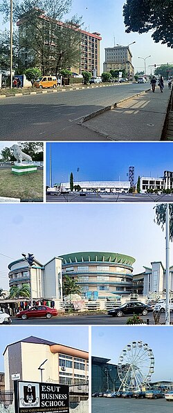
Enugu (/eɪˈnuːɡuː/ ay-NOO-goo;[8] Igbo: Énugwú)[9][10] is the capital city of Enugu State in Nigeria. It is located inland in the Southeastern part of Nigeria. In 2006, the city had a population of 820,000 according to the last Nigerian census.
The name Enugu is derived from the two Igbo words Énú úgwú, meaning "hill top", denoting the city's hilly geography. Enugu acquired township status in 1917 and was called Enugwu-Ngwo. Because of its rapid expansion towards areas owned by other indigenous communities, the city was renamed Enugu in 1928. Since the 17th century the location of present-day Enugu has been inhabited by the Enugwu-Ngwo and Nike (/niːˈkeɪ/ nee-KAY) subgroups of the Igbo people.
In 1900, the colonial administration of the British Empire established the Southern Nigeria Protectorate. After the discovery of coal by colonists, they founded what was then known as the Enugu Coal Camp. It was named after the nearby village of Enugu Ngwo, under which coal was first found.
The nearby city of Port Harcourt was created in order to ship this coal abroad. It was located 243 kilometres (151 mi) south of the camp.[11]
Coal mining opportunities in Enugu attracted people from throughout the region; this marked the core of the first urban settlement of what is today known as simply Enugu. Enugu developed as one of the few cities in West Africa created entirely from European contact. By 1958 Enugu had more than 8,000 coal miners, many managing individual plots. As of 2005[update] there are no significant coal mining activities left in the city.
Enugu became the capital of the Eastern Region after Nigeria's independence in 1960; a succession of territorial adjustments in 1967, 1976 and 1991 resulted in Enugu becoming the capital of what is now Enugu State. On 30 May 1967 Enugu was declared the capital of the short-lived Republic of Biafra; for this Enugu is known as the "capital of Igboland." After Enugu was captured by Nigerian armed forces, the Biafran capital was moved to Umuahia.
Industries in the city include the urban market and bottling industries. Enugu is also a primary filming location for directors of the Nigerian movie industry, and is dubbed "Nollywood". Enugu's main airport is the Akanu Ibiam International Airport.
The 2006 national census in Nigeria estimated the population of Enugu state at 3,267,837.[12] While males constitute 48.84% of the population, the female population constitute 51.16%[13] (1,596,042 males and 1,671,795 females). But, demographers have indicated that the actual population of Enugu state is around six million.[14]
Enugu state has three senatorial zones, namely; Enugu North, Enugu East and Enugu West.[15]
- ^ Cite error: The named reference
townwas invoked but never defined (see the help page). - ^ Cite error: The named reference
capwas invoked but never defined (see the help page). - ^ "Enugu State Population". CityPopulation.
- ^ Duckworth, Edward Harland (1961). "Enugu-Coal Town". Nigeria Magazine (70). Nigeria. Federal Ministry of Information. Cultural Division: 251.
- ^ "FEDERAL REPUBLIC OF NIGERIA : 2006 Population Census" (PDF). Archived from the original (PDF) on 5 March 2012. Retrieved 25 July 2016.
- ^ "Nipost Postcode Map". Nigerian Postal Service. Archived from the original on 7 October 2009. Retrieved 8 May 2010.
- ^ Williams, p. 87.
- ^ Enugu (Dictionary.com Unabridged ed.), Random House, Inc., retrieved 12 June 2010
- ^ Garry, Jane; Rubino, Carl R. Galvez (2001). Facts about the world's languages: an encyclopedia of the world's major languages, past and present. H.W. Wilson. p. 328. ISBN 978-0-8242-0970-4.
- ^ Egbokhare, Francis O.; Oyetade, S. Oluwole (2002). Harmonization and standardization of Nigerian languages. CASAS. p. 106. ISBN 978-1-919799-70-4.
- ^ Nigeria, Chief Secretary's Office (1933). The Nigeria handbook (10 ed.). Eastern Line: Government Printer, Lagos. p. 83.
- ^ "Nigeria – Population Census, State Population- 2006".
- ^ Frances, Okolo. "Nigerian population by State and Sex (2006 Census)".
- ^ "GEOGRAPHICAL LOCATION / DEMOGRAPHY". Archived from the original on 20 October 2019. Retrieved 27 August 2022.
- ^ "List of Senatorial Zones in Enugu State".
© MMXXIII Rich X Search. We shall prevail. All rights reserved. Rich X Search
