Back Erongo Afrikaans إقليم إيرونغو Arabic Erongo AST Еронго Bulgarian Erongo Catalan Erongo (rehiyon) CEB Erongo (region) Czech Erongo German Erongo-regiono Esperanto Región de Erongo Spanish
Erongo Region | |
|---|---|
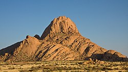
From top, left to right: Bird Island, Spitzkoppe, State House in Swakopmund, View over Walvis Bay, Skeleton Coast. | |
 Location of the Erongo Region in Namibia | |
| Coordinates: 22°00′S 15°35′E / 22.00°S 15.59°E | |
| Country | Namibia |
| Capital | Swakopmund |
| Government | |
| • Governor | Neville Andre Itope[1] |
| Area | |
• Total | 63,539 km2 (24,533 sq mi) |
| Population | |
• Total | 240,206 |
| • Density | 3.8/km2 (9.8/sq mi) |
| Time zone | UTC+2 (CAT) |
| HDI (2017) | 0.711[5] high · 2nd |
| Website | www |
Erongo is one of the 14 regions of Namibia. The capital is Swakopmund. It is named after Mount Erongo, a well-known landmark in Namibia and in this area. Erongo contains the municipalities of Walvis Bay, Swakopmund, Henties Bay and Omaruru, as well as the towns Arandis, Karibib and Usakos. All the main centres within this region are connected by paved roads.
The Erongo Region had a population of 150,809 in 2011.[3] As of 2020, it had 119,784 registered voters.[6]
In the west, Erongo has a shoreline on the Atlantic Ocean. On land, it borders the following regions:
- Kunene - north
- Otjozondjupa - northeast
- Khomas - southeast
- Hardap - south
- ^ "Goodbye". Namibian Sun. 10 April 2020. p. 1. Archived from the original on 2021-05-26. Retrieved 2020-04-09.
- ^ "Namibia's Population by Region". Election Watch (1). Institute for Public Policy Research: 3. 2013.
- ^ a b "Erongo 2011 Census Regional Profile" (PDF). Statistics Namibia. Archived (PDF) from the original on 8 October 2022. Retrieved 10 April 2020.
- ^ "2023 Population & Housing Census Preliminary Report" (PDF). Statistics Namibia.
- ^ "Sub-national HDI - Area Database - Global Data Lab". hdi.globaldatalab.org. Archived from the original on 2018-09-23. Retrieved 2018-09-13.
- ^ "Regional Council 2020 Election Results". Interactive map. Electoral Commission of Namibia. 18 January 2021. Archived from the original on 12 June 2021. Retrieved 11 March 2021.
© MMXXIII Rich X Search. We shall prevail. All rights reserved. Rich X Search


