Back ارسکاینویل، نیو ساوت ولز Persian ארסקינוויל HE Erskineville, New South Wales Romanian 亞士堅胡 Chinese
| Erskineville Sydney, New South Wales | |||||||||||||||
|---|---|---|---|---|---|---|---|---|---|---|---|---|---|---|---|
 | |||||||||||||||
 | |||||||||||||||
| Population | 9,657 (SAL 2021)[1] | ||||||||||||||
| • Density | 5,246.4/km2 (13,588/sq mi) | ||||||||||||||
| Postcode(s) | 2043 | ||||||||||||||
| Area | 1.6 km2 (0.6 sq mi) | ||||||||||||||
| Location | 6 km (4 mi) south west of Sydney CBD | ||||||||||||||
| LGA(s) | City of Sydney | ||||||||||||||
| State electorate(s) | |||||||||||||||
| Federal division(s) | Sydney | ||||||||||||||
| |||||||||||||||
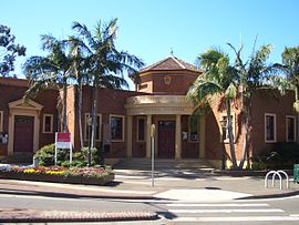
Erskineville (previously known as Macdonaldtown) is a suburb in the Inner West of Sydney, New South Wales, Australia. It is located 6 kilometres south west of the Sydney central business district and is part of the local government area of the City of Sydney. Erskineville is a diverse suburb homing to a wide variety of ethnicity from its varying Southeast Europe and Aboriginal community. Erskineville is colloquially known as Erko.
Erskineville is bordered by the suburbs of Newtown to the west, Redfern to the north, St Peters to the south, and Alexandria to the east. The locality of Macdonaldtown sits over the north-west border.
Erskineville is a residential suburb. Erskineville Oval is located on the eastern border of the suburb.
- ^ Australian Bureau of Statistics (28 June 2022). "Erskineville (suburb and locality)". Australian Census 2021 QuickStats. Retrieved 28 June 2022.
© MMXXIII Rich X Search. We shall prevail. All rights reserved. Rich X Search