Esplanade
| |
|---|---|
| Esplanade and city square | |
 | |
| Opening date | 1786 |
| Owner | Penang Island City Council |
| Location | Jalan Tun Syed Sheh Barakbah and Esplanade Road George Town, Penang, Malaysia |
| Type | Cultural |
| Criteria | ii, iii, iv |
| Designated | 2008 (32nd session) |
| Reference no. | 1223 |
| Region | Asia-Pacific |
| Coordinates: 5°25′19.92″N 100°20′30.948″E / 5.4222000°N 100.34193000°E | |
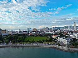
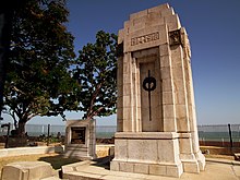
The Esplanade is a seafront city square in the heart of George Town within the Malaysian state of Penang. It covers the field adjacent to Fort Cornwallis, known locally as the Padang, and the seaside promenade along the edge of the field. The City Hall faces the Padang, while the Cenotaph is also located along the promenade.
The Esplanade was the site of a significant event in Penang's history; it was here where Captain Francis Light, the founder of George Town, first landed on 17 July 1786. Upon claiming possession of Penang Island (then Prince of Wales Island) for the British Empire, the Esplanade became the first area to be cleared by Light, while Fort Cornwallis was constructed immediately east of the clearing.
The cleared field was then used as a military parade ground, prior to its recreational and sports use beginning in the mid-19th century. The planned layout of the Padang is similar to that of the Padang in Singapore and Merdeka Square in Kuala Lumpur. The Esplanade is currently a major venue for celebrations and cultural activities in Penang.


© MMXXIII Rich X Search. We shall prevail. All rights reserved. Rich X Search

