Back مقاطعة إيتوا (ألاباما) Arabic ايتووا كاونتى (الاباما) ARZ اتوواه بؤلگهسی، آلاباما AZB Etowah County, Alabama BAR Етоуа (окръг, Алабама) Bulgarian এটৱা কাউন্টি, আলাবামা BPY Etowah Gông (Alabama) CDO Этова (гуо, Алабама) CE Etowah County CEB Etowah County Czech
Etowah County | |
|---|---|
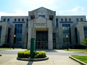
 Etowah County courthouse in Gadsden | |
 Location within the U.S. state of Alabama | |
 Alabama's location within the U.S. | |
| Coordinates: 34°03′00″N 86°02′00″W / 34.05°N 86.033333333333°W | |
| Country | |
| State | |
| Founded | December 1, 1868 |
| Seat | Gadsden |
| Largest city | Gadsden |
| Area | |
| • Total | 549 sq mi (1,420 km2) |
| • Land | 535 sq mi (1,390 km2) |
| • Water | 14 sq mi (40 km2) 2.5% |
| Population (2020) | |
| • Total | 103,436 |
| • Estimate (2023) | 103,241 |
| • Density | 190/sq mi (73/km2) |
| Time zone | UTC−6 (Central) |
| • Summer (DST) | UTC−5 (CDT) |
| Congressional district | 4th |
| Website | www |
| |
Etowah County is a county located in the northeastern part of the U.S. state of Alabama. As of the 2020 census the population was 103,436.[1] Its county seat is Gadsden.[2] Its name is from a Cherokee word meaning "edible tree". In total area, it is the smallest county in Alabama, but one of the most densely populated. Etowah County comprises the Gadsden Metropolitan Statistical Area.
- ^ "State & County QuickFacts". United States Census Bureau. Retrieved September 12, 2023.
- ^ "Find a County". National Association of Counties. Archived from the original on May 31, 2011. Retrieved June 7, 2011.
© MMXXIII Rich X Search. We shall prevail. All rights reserved. Rich X Search