Back Ewhurst (parokya sa Hiniusang Gingharian, Surrey) CEB Ewhurst, Surrey Welsh Ewhurst Spanish Ewhurst (Surrey) French Ewhurst (Surrey) LLD Ewhurst (Surrey) Dutch Ewhurst (Surrey) Polish Ewhurst, Surrey Swedish Ewhurst, Surrey Turkish اوہرسٹ، سرے Urdu
| Ewhurst | |
|---|---|
 | |
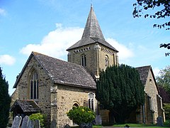
 Church of St Peter and St Paul, Ewhurst | |
Location within Surrey | |
| Area | 23.79 km2 (9.19 sq mi) |
| Population | 2,391 (Civil Parish 2011)[2] |
| • Density | 101/km2 (260/sq mi) |
| OS grid reference | TQ090406 |
| • London | 28 mi (45 km) SW |
| Civil parish |
|
| District | |
| Shire county | |
| Region | |
| Country | England |
| Sovereign state | United Kingdom |
| Post town | Cranleigh |
| Postcode district | GU6 |
| Dialling code | 01483 |
| Police | Surrey |
| Fire | Surrey |
| Ambulance | South East Coast |
| UK Parliament | |
Ewhurst /ˈjuːhɜːrst/ is a rural village and civil parish in the borough of Waverley in Surrey, England. It is located 8.3 miles (13.4 km) south-east of Guildford, 2 miles (3.2 km) east of Cranleigh, and 4.5 miles (7.2 km) south of Shere.[3]
The parish includes the smaller hamlets of Ellen's Green and Cox Green near the border with West Sussex. At the north is Hurt Wood, a part of the Surrey Hills AONB. The Greensand Ridge also passes through this area. The rest of the parish, apart from Ewhurst village itself, is classified as an Area of Great Landscape Value (AGLV).[4]
- ^ Historic England. "Details from listed building database (1190554)". National Heritage List for England. Retrieved 10 October 2012.
- ^ Key Statistics; Quick Statistics: Population Density Archived 11 February 2003 at the Wayback Machine United Kingdom Census 2011 Office for National Statistics Retrieved 21 November 2013
- ^ Grid Reference measurement tools
- ^ "Surrey Hills AGLV Review". Archived from the original on 5 January 2019. Retrieved 19 May 2015.
© MMXXIII Rich X Search. We shall prevail. All rights reserved. Rich X Search
