Back Prats boreals de les Illes Fèroe Catalan Feroaj subarktaj herbejoj Esperanto Pradera boreal de las islas Feroe Spanish Бореальні луки Фарерських островів Ukrainian
| Faroe Islands boreal grasslands | |
|---|---|
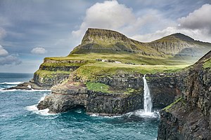
 Waterfall on Vágar Island, Faroe Islands | |
 Ecoregion territory (in purple) | |
| Ecology | |
| Realm | Palearctic |
| Biome | Temperate grasslands, savannas, and shrublands |
| Geography | |
| Area | 1,451 km2 (560 sq mi) |
| Country | Denmark |
| Coordinates | 62°00′N 6°45′W / 62°N 6.75°W |
The Faroe Islands boreal grasslands ecoregion (WWF ID: PA0807) covers all of the territory of the Faroe Islands, an archipelago of 18 islands in the North Atlantic, roughly equidistant between Scotland, Norway, and Iceland.[1][2][3][4] The ground cover is mostly grassland and dwarf shrub heath (about 80% of the land), the remainder is bare ground or sparse vegetation. There are no forests on the islands.[1]
- ^ a b "Faroe Islands boreal grasslands". World Wildlife Federation. Retrieved March 21, 2020.
- ^ "Map of Ecoregions 2017". Resolve, using WWF data. Retrieved September 14, 2019.
- ^ "Faroe Islands boreal grasslands". Digital Observatory for Protected Areas. Retrieved August 1, 2020.
- ^ "Faroe Islands boreal grasslands". The Encyclopedia of Earth. Retrieved August 28, 2020.
© MMXXIII Rich X Search. We shall prevail. All rights reserved. Rich X Search