Back Fisterra AN فيستيرا Arabic فیسترا AZB Fisterra Breton Fisterra Catalan Финистерре (Ла-Корунья) CE Fisterra (munisipyo) CEB Fisterra Czech Fisterra German Fisterra DIQ
Fisterra | |
|---|---|
 | |
 | |
| Coordinates: 42°54′N 9°15′W / 42.900°N 9.250°W | |
| Country | |
| Autonomous community | |
| Province | A Coruña |
| Comarca | Fisterra |
| Government | |
| • Mayor | José Manuel Traba Fernández |
| Area | |
| • Total | 29.43 km2 (11.36 sq mi) |
| Population (2018)[1] | |
| • Total | 4,701 |
| • Density | 160/km2 (410/sq mi) |
| Demonym(s) | fisterrán, -á |
| Time zone | UTC+1 (CET) |
| • Summer (DST) | UTC+2 (CEST) |
| Postal code | 15155 |
| Dialing code | 981 |
| Website | Official website |


Fisterra (Galician pronunciation: [fisˈtɛrɐ]; Spanish: Finisterre [finisˈtere]) is a municipality in the province of A Coruña, in the autonomous community of Galicia, Spain. It belongs to the comarca of Fisterra. Fisterra is on Cape Finisterre, an alternative final destination for pilgrims on the Way of St. James who seek to travel beyond Santiago de Compostella.
Fisterra is on the rocky Costa da Morte (Galician: "Coast of Death"), named because of the large number of shipwrecks along these shores. The name Fisterra comes from Latin FINIS TERRAE, meaning "Land's End". This name stems from the fact that this area is on a remote peninsula that is one of the westernmost points of land in Galicia, and hence in Spain.
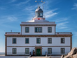
Fisterra is an ancient port and fishing village, formed by narrow streets leading to the Plaza de Ara Solis. The chapel of Nosa Señora do Bon Suceso, dating from the 18th century, is on the plaza. There is a lighthouse on a 600-metre promontory called "Monte Facho" at the tip of Cape Finisterre overlooking the Atlantic Ocean. On the road up to the lighthouse is the parish church of Santa María de Fisterra which contains the Chapel of Santo Cristo.
Fisterra is 108 km from A Coruña, and 98 km from Santiago de Compostela.

- ^ Municipal Register of Spain 2018. National Statistics Institute.
© MMXXIII Rich X Search. We shall prevail. All rights reserved. Rich X Search

