Back Fitzroy Island (pulo sa Ostralya) CEB Île Fitzroy French Fitzroy Island, Queensland ID Fitzroy Island Italian Ilha Fitzroy (Queensland) Portuguese Fitzroy Island (ö i Australien) Swedish فزروئے جزیرہ (کوئینز لینڈ) Urdu 斐茲洛伊島 Chinese
Native name: Koba or Gabar or Goong-Gan-Jee | |
|---|---|
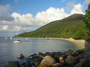
 Welcome Bay, Fitzroy Island | |
 | |
| Geography | |
| Location | Coral Sea |
| Coordinates | 16°56′S 146°00′E / 16.933°S 146.000°E |
| Area | 11.6 km2 (4.5 sq mi) |
| Highest elevation | 240 m (790 ft) |
| Administration | |
Australia | |
| State | Queensland |
| LGA | Cairns Region |
| Demographics | |
| Population | 85 (2021) |
| Fitzroy Island Gabar or Goong-Gan-Jee Island Cairns, Queensland | |
|---|---|
 | |
| Coordinates | 16°55′49″S 145°59′32″E / 16.9302°S 145.9922°E |
| Population | 85 (2021 census)[1] |
| • Density | 7.33/km2 (18.98/sq mi) |
| Postcode(s) | 4871 |
| Area | 11.6 km2 (4.5 sq mi) |
| Time zone | AEST (UTC+10:00) |
| LGA(s) | Cairns Region |
| State electorate(s) | Mulgrave |
| Federal division(s) | Kennedy |
Fitzroy Island (originally Koba or Gabar or Goong-Gan-Jee) is a continental island offshore from Cape Grafton, 29 km (18 miles) southeast of Cairns, Queensland, Australia. It is a locality in the Cairns Region.[2][3] In the 2021 census, Fitzroy Island had a population of 85 people.[1]
- ^ a b Cite error: The named reference
Census2021was invoked but never defined (see the help page). - ^ "Fitzroy Island – locality in Cairns Region (entry 48635)". Queensland Place Names. Queensland Government. Retrieved 30 July 2017.
- ^ "Fitzroy Island (Goon-Gan-Jee Island) – Island in Cairns Region (entry 12563)". Queensland Place Names. Queensland Government. Retrieved 7 May 2018.
© MMXXIII Rich X Search. We shall prevail. All rights reserved. Rich X Search
