Back Fort Necessity National Battlefield CEB Champ de bataille national de Fort Necessity French ფორტი ნესესითი Georgian फोर्ट नेसेसिटी Marathi
| Fort Necessity National Battlefield | |
|---|---|
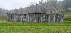
 The reconstructed Fort Necessity | |
| Location | Wharton Township, Fayette, Pennsylvania, United States |
| Coordinates | 39°48′55″N 79°35′22″W / 39.81528°N 79.58944°W |
| Area | 902.8 acres (365.4 ha)[2] |
| Elevation | 1,955 ft (596 m) |
| Established | March 4, 1931[2] |
| Website | Fort Necessity National Battlefield |
Fort Necessity National Battlefield | |
| Nearest city | Uniontown |
| NRHP reference No. | 66000664[3] |
| Added to NRHP | October 15, 1966 |
Fort Necessity National Battlefield is a National Battlefield in Fayette County, Pennsylvania, United States, which preserves the site of the Battle of Fort Necessity. The battle, which took place on July 3, 1754, was an early battle of the French and Indian War, and resulted in the surrender of British colonial forces under Colonel George Washington, to the French and Indians, under Louis Coulon de Villiers.
The site also includes the Mount Washington Tavern, once one of the inns along the National Road, and in two separate units the grave of British General Edward Braddock, killed in 1755, and the site of the Battle of Jumonville Glen.
- ^ "Fort Necessity National Battlefield". Protected Planet. IUCN. Retrieved May 6, 2018.
- ^ a b "Home Page for the Stewardship and Partnerships Team". National Park Service; Philadelphia Support Office. Retrieved June 30, 2009.
- ^ "National Register Information System". National Register of Historic Places. National Park Service. July 9, 2010. Retrieved July 16, 2013.
© MMXXIII Rich X Search. We shall prevail. All rights reserved. Rich X Search

