Back Которска крепост Bulgarian Οχυρώσεις του Κότορ Greek Fortificaciones de Kotor Spanish Կոտորի պաշտպանական կառույցներ Armenian Perbentengan Kotor ID Fortificazioni di Cattaro Italian 코토르 성벽 Korean Которска тврдина Macedonian Fortifikazzjonijiet ta’ Kotor Maltese Fortyfikacje Kotoru Polish
| Fortifications of Kotor | |
|---|---|
| Kotor in Montenegro | |
 | |
| Coordinates | 42°25′25″N 18°46′19″E / 42.42361°N 18.77194°E |
| Part of | Natural and Culturo-Historical Region of Kotor |
| Criteria | Cultural: (i)(ii)(iii)(iv) |
| Reference | 125ter |
| Inscription | 1979 (3rd Session) |
| Extensions | 2012, 2015 |
| Endangered | 1979–2003[1] |
| Official name | Fortified city of Kotor |
| Part of | Venetian Works of Defence between the 16th and 17th Centuries: Stato da Terra – Western Stato da Mar |
| Criteria | Cultural: (iii)(iv) |
| Reference | 1533-006 |
| Inscription | 2017 (41st Session) |
| Area | 16.32 ha (40.3 acres) |
| Buffer zone | 99.19 ha (245.1 acres) |


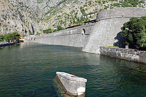
The fortifications of Kotor (Italian: Cattaro) are an integrated historical fortification system that protected the medieval town of Kotor containing ramparts, towers, citadels, gates, bastions, forts, cisterns, a castle, and ancillary buildings and structures. They incorporate military architecture of Illyria, the Byzantine Empire, Venice, and Austria. Together with the old town and its natural surroundings the fortifications were inscribed in the list of World Heritage Sites in 1979 labelled Natural and Culturo-Historical Region of Kotor and represent the only such site of cultural significance in Montenegro.
The fortified city of Kotor was also included in UNESCO's World Heritage Site list as part of Venetian Works of Defence between 15th and 17th centuries: Stato da Terra – western Stato da Mar in 2017.[2]
- ^ State of Conservation: Natural and Culturo-Historical Region of Kotor (2003) at UNESCO website.
- ^ Centre, UNESCO World Heritage. "Venetian Works of Defence between 15th and 17th centuries: Stato da Terra – western Stato da Mar". whc.unesco.org. Retrieved 11 July 2017.
© MMXXIII Rich X Search. We shall prevail. All rights reserved. Rich X Search
