Back Fra Mauro xəritəsi Azerbaijani Mapamundi de Fra Mauro Catalan Mapa otce Maura Czech Fra Mauros Weltkarte German Παγκόσμιος χάρτης του πατρός Μάουρο Greek Mapo de Fra Mauro Esperanto Mapamundi de Fra Mauro Spanish نقشه فرا مائورو Persian Carte de Fra Mauro French Peta Fra Mauro ID

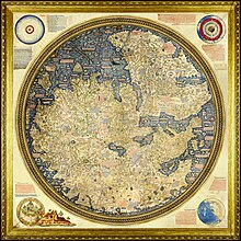
The Fra Mauro map is a map of the world made around 1450 by the Italian (Venetian) cartographer Fra Mauro, which is “considered the greatest memorial of medieval cartography."[1] It is a circular planisphere drawn on parchment and set in a wooden frame that measures over two by two meters. Including Asia, the Indian Ocean, Africa, Europe, and the Atlantic, it is orientated with south at the top. The map is usually on display in the Biblioteca Nazionale Marciana in Venice in Italy.
The Fra Mauro world map is a major cartographical work.[2] It took several years to complete and was very expensive to produce. The map contains hundreds of detailed illustrations and more than 3000 descriptive texts. It was the most detailed and accurate representation of the world that had been produced up until that time. As such, the Fra Mauro map is considered one of the most important works in the history of cartography. According to Jerry Brotton, it marked "the beginning of the end of early medieval mappae mundi that reflected biblical geographical teaching." It placed accuracy ahead of religious or traditional beliefs, breaking with tradition, for example, by not placing Jerusalem at the center of the world and not showing a physical location for the biblical Paradise.[3]
The maker of the map, Fra Mauro, was a Camaldolese monk from the island of Murano near Venice. He was employed as an accountant and professional cartographer. The map was made for the rulers of Venice and Portugal, two of the main seafaring nations of the time.
- ^ Almagià 1944, pp. 32–40, discussing the copy of another map by Fra Mauro, in the Vatican Library.
- ^ Siebold 2015
- ^ Brotton 2014
© MMXXIII Rich X Search. We shall prevail. All rights reserved. Rich X Search