Back فرانكلين (ميزوري) Arabic فرانكلين (هاوارد) ARZ فرانکلین، میزوری AZB Franklin (Missouri) Catalan Франклин (Миссури) CE Franklin (Missouri) German Franklin (Misuri) Spanish Franklin (Missouri) Basque فرانکلین، میزوری Persian Franklin (Missouri) French
Franklin, Missouri | |
|---|---|
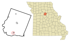
 Location of Franklin, Missouri | |
| Coordinates: 39°0′41″N 92°45′13″W / 39.01139°N 92.75361°W | |
| Country | United States |
| State | Missouri |
| County | Howard |
| Area | |
| • Total | 0.23 sq mi (0.61 km2) |
| • Land | 0.23 sq mi (0.60 km2) |
| • Water | 0.00 sq mi (0.01 km2) |
| Elevation | 597 ft (182 m) |
| Population (2020) | |
| • Total | 70 |
| • Density | 303.03/sq mi (117.01/km2) |
| Time zone | UTC-6 (Central (CST)) |
| • Summer (DST) | UTC-5 (CDT) |
| ZIP code | 65250 |
| Area code | 660 |
| FIPS code | 29-25624[2] |
| GNIS feature ID | 0718163[3] |
Franklin is a city in Howard County, Missouri, United States. It is located along the Missouri River in the central part of the state. Located in a rural area, the city had a population of 70 at the 2020 census.[4] It is part of the Columbia, Missouri Metropolitan Statistical Area.
As the eastern terminus of the Santa Fe Trail, the community played a major role in the westward expansion of the United States.
- ^ "ArcGIS REST Services Directory". United States Census Bureau. Retrieved August 28, 2022.
- ^ "U.S. Census website". United States Census Bureau. Retrieved January 31, 2008.
- ^ "US Board on Geographic Names". United States Geological Survey. October 25, 2007. Retrieved January 31, 2008.
- ^ "Explore Census Data". data.census.gov. Retrieved January 5, 2022.
© MMXXIII Rich X Search. We shall prevail. All rights reserved. Rich X Search