| Frays River | |
|---|---|
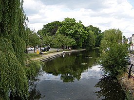
 Frays River in Frays Farm Meadows | |
| Location | |
| Country | England |
| County | Buckinghamshire, London Borough of Hillingdon |
| Physical characteristics | |
| Source | |
| • location | River Colne, Denham Weir, Buckinghamshire |
| • coordinates | 51°33′58″N 0°29′00″W / 51.5661°N 0.4832°W |
| • elevation | 35 m (115 ft) |
| Mouth | |
• location | River Colne, West Drayton |
• coordinates | 51°29′58″N 0°29′05″W / 51.4995°N 0.4848°W |
• elevation | 24 m (79 ft) |
| Length | 5.5 mi (8.9 km) |
| Basin features | |
| Tributaries | |
| • left | River Pinn |
Frays River is a semi-canalised short river in England that branches off the River Colne at Uxbridge Moor and rejoins it at West Drayton. It is believed to be a mainly man-made anabranch north of the confluence with the River Pinn to feed watermills in the Parish of Hillingdon. The river is believed to be named after John Fray who owned Cowley Hall in the fifteenth century. Other names for the river are the Uxbridge and Cowley Mill Stream, the Cowley Stream or the Colham Mill Stream. Two of the three mills in Hillingdon Parish recorded in the Domesday book are believed to have been located on the southern section of the river.[1]

- ^ "A History of the County of Middlesex Volume 4, Hillingdon, including Uxbridge: Economic and social history". www.british-history.ac.uk. London: Victoria County History. 1971. pp. 75–82. Retrieved 23 December 2020.
© MMXXIII Rich X Search. We shall prevail. All rights reserved. Rich X Search
