Back مطار فولرتون المحلى ARZ Fullerton Municipal Airport CEB Aeropuerto Municipal de Fullerton Spanish فرودگاه شهری فولرتن Persian Mąʼii Dah Daaskʼidi chidí naatʼaʼí ńdinibįįhígi NV Aeroportul Municipal Fullerton Romanian Фурудгоҳи шаҳре фулртн Tajik فلرٹن میونسپل ہوائی اڈا Urdu
Fullerton Municipal Airport | |||||||||||
|---|---|---|---|---|---|---|---|---|---|---|---|
 | |||||||||||
| Summary | |||||||||||
| Airport type | Public | ||||||||||
| Operator | City of Fullerton | ||||||||||
| Location | Fullerton, California | ||||||||||
| Elevation AMSL | 96 ft / 29.3 m | ||||||||||
| Coordinates | 33°52′19.25″N 117°58′47.22″W / 33.8720139°N 117.9797833°W | ||||||||||
| Runways | |||||||||||
| |||||||||||
| Helipads | |||||||||||
| |||||||||||
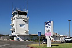
Fullerton Municipal Airport (IATA: FUL, ICAO: KFUL), owned and operated by the City of Fullerton, is a regional relief airport in Orange County, California.[1]
The airport is in the southwestern corner of Fullerton on Commonwealth Avenue, northeast of the junction of the Santa Ana (I-5) and Riverside (SR 91) Freeways. The airport and its industrial park are surrounded by residential areas. It is popular among private pilots traveling within the state of California, but there are occasional flights to and from Nevada, Arizona and Utah.[2]
- ^ "2015–2019 NPIAS Report, Appendix A" (PDF). Federal Aviation Administration. January 20, 2015. Archived from the original (PDF, 7.89 MB) on 2016-02-22.
- ^ "Lists of scheduled arrivals/departures" | publisher = FlightAware flight tracking database for KFUL | date = October 22, 2016
© MMXXIII Rich X Search. We shall prevail. All rights reserved. Rich X Search