Back Garden-eiland Afrikaans جاردين ARZ Garden Island (pulo sa Ostralya, State of Western Australia) CEB Garden Island (Australie-Occidentale) French Garden Island (Australia Occidentale) Italian Garden Island (West-Australië) Dutch Garden Island (ö i Australien, Western Australia) Swedish
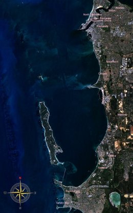
 Garden Island and Cockburn Sound from space (NASA World Wind) | |
 | |
| Geography | |
|---|---|
| Location | Indian Ocean |
| Coordinates | 32°11′39″S 115°40′27″E / 32.19417°S 115.67417°E |
| Area | 11 km2 (4.2 sq mi) |
| Administration | |
| Demographics | |
| Population | 772 (SAL 2021)[1] |
| Official name | Garden Island |
| Type | Listed place (Natural) |
| Designated | 22 June 2004 |
| Reference no. | 105274 |
Garden Island (Noongar: Meandup or Meeandip) is a narrow island about 10 kilometres (6 mi) long and 1.5 kilometres (0.9 mi) wide, lying about 5 kilometres (3 mi) off the Western Australian coast, to which it is linked by an artificial causeway and bridge.
Like Rottnest Island and Carnac Island, it is a limestone outcrop covered by a thin layer of sand accumulated during an era of lowered sea levels.[2] The Noongar peoples tell of walking to these islands in their Dreamtime.
At the end of the last glacial period, the sea level rose, cutting the island off from the mainland. For the last seven thousand years, the island has existed in relative isolation.
The Royal Australian Navy's largest fleet base, Fleet Base West, also called HMAS Stirling,[3] is on the shores of Careening Bay, on the southeastern section of Garden Island, facing Cockburn Sound. At the 2016 census,[update] 720 people lived on the Garden Island base.[4]
The entirety of Garden Island is included on the Commonwealth Heritage List for its natural values. Garden Island is home to a tammar wallaby population.[5]
- ^ Australian Bureau of Statistics (28 June 2022). "Garden Island (WA) (suburb and locality)". Australian Census 2021 QuickStats. Retrieved 28 June 2022.
- ^ "Natural History". Rottnest Island Authority. Retrieved 22 January 2021.
- ^ "RAN website on HMAS Stirling".
- ^ ABS
- ^ "Garden Island, WA, Australia". Australian Government Department of Agriculture, Water and the Environment. Retrieved 22 January 2021.
© MMXXIII Rich X Search. We shall prevail. All rights reserved. Rich X Search