Back مقاطعة غارفين (أوكلاهوما) Arabic Garvin County, Oklahoma BAR Гарвин (окръг, Оклахома) Bulgarian গারভিন কাউন্টি, ওকলাহোমা BPY Garvin Gông (Oklahoma) CDO Garvin County CEB Garvin County, Oklahoma Welsh Garvin County German Condado de Garvin Spanish Garvin konderria (Oklahoma) Basque
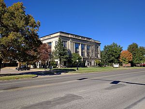
Garvin County | |
|---|---|
 | |
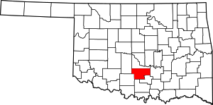
 Location within the U.S. state of Oklahoma | |
 Oklahoma's location within the U.S. | |
| Coordinates: 34°43′N 97°19′W / 34.71°N 97.31°W | |
| Country | |
| State | |
| Founded | 1906[1] |
| Named for | Samuel J. Garvin[1] |
| Seat | Pauls Valley |
| Largest city | Pauls Valley |
| Area | |
| • Total | 814 sq mi (2,110 km2) |
| • Land | 802 sq mi (2,080 km2) |
| • Water | 12 sq mi (30 km2) 1.4% |
| Population (2020) | |
| • Total | 25,656 |
| • Density | 32/sq mi (12/km2) |
| Time zone | UTC−6 (Central) |
| • Summer (DST) | UTC−5 (CDT) |
| Congressional district | 4th |
Garvin County is a county in south-central Oklahoma, United States. As of the 2020 census, the population was 25,656.[2] Its county seat is Pauls Valley.[3] In 1906, delegates to Constitution Convention formed Garvin County from part of the Chickasaw Nation, Indian Territory. The county was named for Samuel J. Garvin, a local Chickasaw rancher, merchant and banker. Its economy is largely based on farming, ranching and oil production.[1]
- ^ a b c Lough, D. Keith. "Oklahoma Encyclopedia of History and Culture - Garvin County". Retrieved April 4, 2015.
- ^ "Garvin County, Oklahoma". United States Census Bureau. Retrieved May 12, 2023.
- ^ "Find a County". National Association of Counties. Archived from the original on May 31, 2011. Retrieved June 7, 2011.
© MMXXIII Rich X Search. We shall prevail. All rights reserved. Rich X Search