Back Ledenez Gazelle Breton Gazelle Peninsula CEB Gazelle-Halbinsel German Península de Gazelle Spanish Péninsule de Gazelle French Penisola Gazelle Italian Gazelle (półwysep) Polish 加泽尔半岛 Chinese


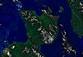
The Gazelle Peninsula is a large peninsula in northeastern East New Britain, Papua New Guinea located on the island of New Britain within the Bismarck Archipelago, situated in the southwestern Pacific Ocean. The Rabaul caldera is located on the northern tip of the peninsula. Upon the Gazelle Peninsula are the Baining Mountains, of which the highest point is Mount Sinewit at 2,063 m (6,768 ft).[2][3] The Gazelle Peninsula houses Vulcan Crater and Mount Tavurvur, both of which conducted volcanic activity in the 20th and 21st centuries and have provided extremely fertile soils. The body of the Gazelle Peninsula is about 80 km (50 mi). The southern isthmus upon which the Gazelle Peninsula is connected to the main body of East New Britain is reduced to about 32 km (20 mi). [4]
- ^ Andree, R. (1895). New Guinea, Papuan Archipelago (Online image). Retrieved April 22, 2019 from https://www.davidrumsey.com/luna/servlet/detail/RUMSEY~8~1~31748~1150678#
- ^ "Summit of Mount Sinewit". wikimapia.
- ^ "Mount Sinewit, Papua New Guinea". Peakbagger.com.
- ^ The Editors of Encyclopædia Britannica, (2015). Gazelle peninsula. Retrieved April 23, 2019 from https://www.britannica.com/place/Gazelle-Peninsula
© MMXXIII Rich X Search. We shall prevail. All rights reserved. Rich X Search